Binarowa geodata
Binarowa (Lesser Poland) is a populated place; located in Poland in Europe/Warsaw (GMT+2) time zone. With population of 1,763 people, there are 1644 cities with bigger population in this country. Compared to other cities in Poland, 92.9% of cities are located further ↑North; 76.1% of cities are located further ←West and 81% of cities have lower elevation than Binarowa. Note1


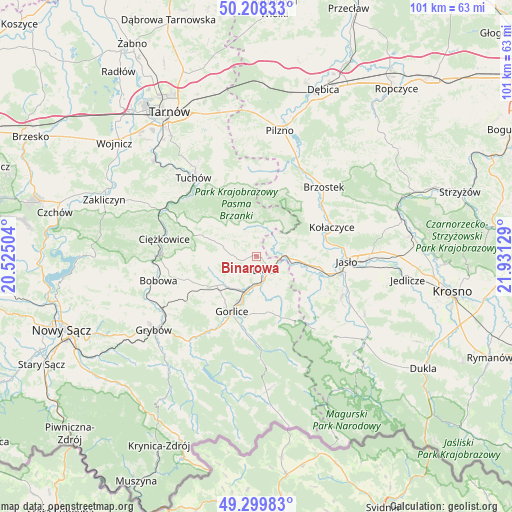
Binarowa GPS coordinates[2]
49° 45' 22.356" North, 21° 13' 41.376" East
| Map corner | latitude | longitude |
|---|---|---|
| Upper-left | 50.20833°, | 20.52504° |
| Center: | 49.75621°, | 21.22816° |
| Lower-right: | 49.29983°, | 21.93129° |
| Map W x H: | 101×101 km | = 62.8×62.8mi |
| max Lat: | 54.83135° ⇑92.9% North |
| Binarowa: | 49.75621° |
| min Lat: | ⇓7.1% South 49.21328° |
| min Long | Binarowa | max Long |
| 14.20249° | 21.22816° | 24.03723° |
| W 76.1%⇐ | ⇒23.9% E |
Elevation
Elevation of Binarowa is 270 m = 886 ft, and this is 78.6 m = 258 ft above average elevation for this country.
| Max E: |
974 m = 3196 ft | 19% |
| Binarowa | 270 m 886 ft | |
| Avg. | 191.4 m = 628 ft | |
Min E: |
-3 m = -10 ft | 81% |
See also: Poland elevation on elevation.city.
Geographical zone
Binarowa is located in North temperate zone (between Tropic of Cancer and the Arctic Circle). Distance of this North polar circle is 1868.8 km =1161.2 mi to North.| Distance of | km | miles | from Binarowa |
|---|---|---|---|
| North Pole | 4474.7 | 2780.4 | to North |
| Arctic Circle | 1868.8 | 1161.2 | to North |
| Tropic Cancer | 2926.5 | 1818.4 | to South |
| Equator | 5532.4 | 3437.7 | to South |


Nearby cities:
15 places around Binarowa: (largest is in red/bold)
• Biecz
3.4 km =2.1 mi,  131°
131°
• Gorlice
12.2 km =7.6 mi,  203°
203°
• Jabłonica
8.3 km =5.2 mi,  59°
59°
• Kobylanka
9.7 km =6 mi,  182°
182°
• Korczyna
5.1 km =3.2 mi,  161°
161°
• Kwiatonowice
6.1 km =3.8 mi,  230°
230°
• Lipinki
10.4 km =6.5 mi,  153°
153°
• Lipnica Dolna
11.6 km =7.2 mi,  74°
74°
• Moszczenica
10 km =6.2 mi,  257°
257°
• Ołpiny
5.9 km =3.7 mi,  343°
343°
• Racławice
2.9 km =1.8 mi,  254°
254°
• Skołyszyn
7.8 km =4.8 mi,  95°
95°
• Szerzyny
6 km =3.7 mi,  12°
12°
• Wróblowa
12.9 km =8 mi, 73°
• Żurowa
8.9 km =5.5 mi,  331°
331°
Sources, notices
• [Note1] Compared only with cities in Poland existing in our database
• [Src1] Map data: © OpenStreetMap contributors (CC-BY-SA)
• [Src2] Other city data from geonames.org with taken over terms of usage.
• [Src3] Geographical zone / Annual Mean Temperature by Robert A. Rohde @ Wikipedia
