Bobowa geodata
Bobowa (Lesser Poland) is a populated place; located in Poland in Europe/Warsaw (GMT+2) time zone. With population of 3,018 people, there are 1036 cities with bigger population in this country. Compared to other cities in Poland, 94.4% of cities are located further ↑North; 71.6% of cities are located further ←West and 83.9% of cities have lower elevation than Bobowa. Note1


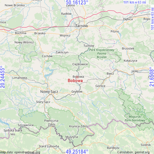
Bobowa GPS coordinates[2]
49° 42' 31.176" North, 20° 56' 51.612" East
| Map corner | latitude | longitude |
|---|---|---|
| Upper-left | 50.16123°, | 20.24455° |
| Center: | 49.70866°, | 20.94767° |
| Lower-right: | 49.25184°, | 21.6508° |
| Map W x H: | 101.1×101.1 km | = 62.8×62.8mi |
| max Lat: | 54.83135° ⇑94.4% North |
| Bobowa: | 49.70866° |
| min Lat: | ⇓5.6% South 49.21328° |
| min Long | Bobowa | max Long |
| 14.20249° | 20.94767° | 24.03723° |
| W 71.6%⇐ | ⇒28.4% E |
Elevation
Elevation of Bobowa is 285 m = 935 ft, and this is 93.6 m = 307 ft above average elevation for this country.
| Max E: |
974 m = 3196 ft | 16.1% |
| Bobowa | 285 m 935 ft | |
| Avg. | 191.4 m = 628 ft | |
Min E: |
-3 m = -10 ft | 83.9% |
See also: Poland elevation on elevation.city.
Geographical zone
Bobowa is located in North temperate zone (between Tropic of Cancer and the Arctic Circle). Distance of this North polar circle is 1874.1 km =1164.5 mi to North.| Distance of | km | miles | from Bobowa |
|---|---|---|---|
| North Pole | 4480 | 2783.7 | to North |
| Arctic Circle | 1874.1 | 1164.5 | to North |
| Tropic Cancer | 2921.2 | 1815.1 | to South |
| Equator | 5527.1 | 3434.4 | to South |


Nearby cities:
15 places around Bobowa: (largest is in red/bold)
• Bystra
11.2 km =7 mi,  117°
117°
• Ciężkowice
8.8 km =5.5 mi,  12°
12°
• Gromnik
14.5 km =9 mi,  3°
3°
• Grybów
9.4 km =5.8 mi,  179°
179°
• Gródek Nad Dunajcem
16 km =9.9 mi,  285°
285°
• Jastrzębia
11 km =6.8 mi,  334°
334°
• Korzenna
7.9 km =4.9 mi,  251°
251°
• Kwiatonowice
15.5 km =9.6 mi,  85°
85°
• Lipnica Wielka
5.7 km =3.5 mi,  265°
265°
• Moszczenica
10.9 km =6.8 mi,  73°
73°
• Ropa
14.8 km =9.2 mi,  151°
151°
• Rzepiennik Marciszewski
14.2 km =8.8 mi,  16°
16°
• Rzepiennik Strzyżewski
12.5 km =7.8 mi,  30°
30°
• Siedlce
12.6 km =7.8 mi,  259°
259°
• Łużna
7.1 km =4.4 mi, 86°
Sources, notices
• [Note1] Compared only with cities in Poland existing in our database
• [Src1] Map data: © OpenStreetMap contributors (CC-BY-SA)
• [Src2] Other city data from geonames.org with taken over terms of usage.
• [Src3] Geographical zone / Annual Mean Temperature by Robert A. Rohde @ Wikipedia
