Biecz geodata
Biecz (Lesser Poland) is a populated place; located in Poland in Europe/Warsaw (GMT+2) time zone. With population of 4,564 people, there are 724 cities with bigger population in this country. Compared to other cities in Poland, 93.4% of cities are located further ↑North; 76.6% of cities are located further ←West and 77% of cities have lower elevation than Biecz. Note1


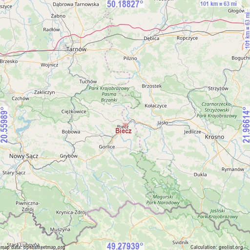
Biecz GPS coordinates[2]
49° 44' 9.456" North, 21° 15' 46.836" East
| Map corner | latitude | longitude |
|---|---|---|
| Upper-left | 50.18827°, | 20.55989° |
| Center: | 49.73596°, | 21.26301° |
| Lower-right: | 49.27939°, | 21.96614° |
| Map W x H: | 101.1×101.1 km | = 62.8×62.8mi |
| max Lat: | 54.83135° ⇑93.4% North |
| Biecz: | 49.73596° |
| min Lat: | ⇓6.6% South 49.21328° |
| min Long | Biecz | max Long |
| 14.20249° | 21.26301° | 24.03723° |
| W 76.6%⇐ | ⇒23.4% E |
Elevation
Elevation of Biecz is 254 m = 833 ft, and this is 62.6 m = 205 ft above average elevation for this country.
| Max E: |
974 m = 3196 ft | 23% |
| Biecz | 254 m 833 ft | |
| Avg. | 191.4 m = 628 ft | |
Min E: |
-3 m = -10 ft | 77% |
See also: Poland elevation on elevation.city.
Geographical zone
Biecz is located in North temperate zone (between Tropic of Cancer and the Arctic Circle). Distance of this North polar circle is 1871.1 km =1162.6 mi to North.| Distance of | km | miles | from Biecz |
|---|---|---|---|
| North Pole | 4476.9 | 2781.8 | to North |
| Arctic Circle | 1871.1 | 1162.6 | to North |
| Tropic Cancer | 2924.2 | 1817 | to South |
| Equator | 5530.1 | 3436.2 | to South |


Nearby cities:
15 places around Biecz: (largest is in red/bold)
• Binarowa
3.4 km =2.1 mi,  311°
311°
• Gorlice
11.6 km =7.2 mi,  219°
219°
• Jabłonica
7.9 km =4.9 mi,  36°
36°
• Kobylanka
8 km =5 mi,  201°
201°
• Korczyna
2.8 km =1.7 mi, 198°
• Kwiatonowice
7.4 km =4.6 mi,  256°
256°
• Lipinki
7.3 km =4.5 mi,  162°
162°
• Lipnica Dolna
10.1 km =6.3 mi,  58°
58°
• Ołpiny
8.9 km =5.5 mi,  332°
332°
• Racławice
5.5 km =3.4 mi,  285°
285°
• Skołyszyn
5.5 km =3.4 mi,  74°
74°
• Szerzyny
8.2 km =5.1 mi,  351°
351°
• Trzcinica
11.1 km =6.9 mi,  85°
85°
• Wróblowa
11.5 km =7.1 mi, 58°
• Żurowa
12.1 km =7.5 mi, 326°
Sources, notices
• [Note1] Compared only with cities in Poland existing in our database
• [Src1] Map data: © OpenStreetMap contributors (CC-BY-SA)
• [Src2] Other city data from geonames.org with taken over terms of usage.
• [Src3] Geographical zone / Annual Mean Temperature by Robert A. Rohde @ Wikipedia
