Przemyśl geodata
Przemyśl (Subcarpathian) is a seat of a second-order administrative division; located in Poland in Europe/Warsaw (GMT+2) time zone. With population of 67,013 people, there are 74 cities with bigger population in this country. Compared to other cities in Poland, 92.3% of cities are located further ↑North; 94.3% of cities are located further ←West and 57.7% of cities have lower elevation than Przemyśl. Note1


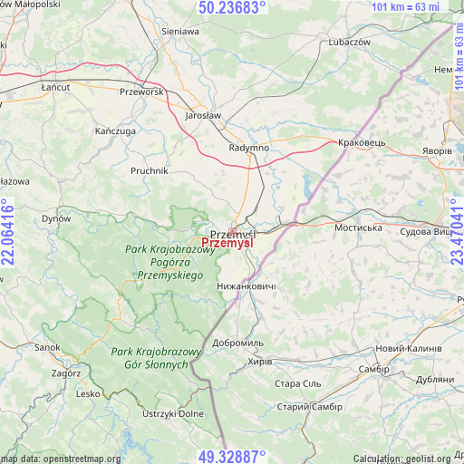
Przemyśl GPS coordinates[2]
49° 47' 5.928" North, 22° 46' 2.208" East
| Map corner | latitude | longitude |
|---|---|---|
| Upper-left | 50.23683°, | 22.06416° |
| Center: | 49.78498°, | 22.76728° |
| Lower-right: | 49.32887°, | 23.47041° |
| Map W x H: | 101×101 km | = 62.8×62.8mi |
| max Lat: | 54.83135° ⇑92.3% North |
| Przemyśl: | 49.78498° |
| min Lat: | ⇓7.7% South 49.21328° |
| min Long | Przemyśl | max Long |
| 14.20249° | 22.76728° | 24.03723° |
| W 94.3%⇐ | ⇒5.7% E |
Elevation
Elevation of Przemyśl is 193 m = 633 ft, and this is 1.6 m = 5 ft above average elevation for this country.
| Max E: |
974 m = 3196 ft | 42.3% |
| Przemyśl | 193 m 633 ft | |
| Avg. | 191.4 m = 628 ft | |
Min E: |
-3 m = -10 ft | 57.7% |
See also: Przemyśl elevation on elevation.city.
Geographical zone
Przemyśl is located in North temperate zone (between Tropic of Cancer and the Arctic Circle). Distance of this North polar circle is 1865.6 km =1159.2 mi to North.| Distance of | km | miles | from Przemyśl |
|---|---|---|---|
| North Pole | 4471.5 | 2778.5 | to North |
| Arctic Circle | 1865.6 | 1159.2 | to North |
| Tropic Cancer | 2929.7 | 1820.4 | to South |
| Equator | 5535.6 | 3439.7 | to South |


Nearby cities:
15 places around Przemyśl: (largest is in red/bold)
• Chłopice
19.4 km =12.1 mi,  339°
339°
• Fredropol
10 km =6.2 mi,  188°
188°
• Krasiczyn
8.3 km =5.2 mi,  263°
263°
• Krzywcza
16 km =9.9 mi,  275°
275°
• Małkowice
9.1 km =5.7 mi,  28°
28°
• Medyka
11.4 km =7.1 mi,  78°
78°
• Nakło
17.3 km =10.7 mi,  53°
53°
• Orły
9.9 km =6.2 mi,  14°
14°
• Radymno
18.5 km =11.5 mi, 12°
• Rokietnica
15.6 km =9.7 mi,  324°
324°
• Ruszelczyce
18 km =11.2 mi, 279°
• Sośnica
15 km =9.3 mi, 30°
• Stubno
18.5 km =11.5 mi, 47°
• Węgierka
18.8 km =11.7 mi,  307°
307°
• Żurawica
4.6 km =2.9 mi,  20°
20°
Sources, notices
• [Note1] Compared only with cities in Poland existing in our database
• [Src1] Map data: © OpenStreetMap contributors (CC-BY-SA)
• [Src2] Other city data from geonames.org with taken over terms of usage.
• [Src3] Geographical zone / Annual Mean Temperature by Robert A. Rohde @ Wikipedia
