Krasiczyn geodata
Krasiczyn (Subcarpathian) is a seat of a third-order administrative division; located in Poland in Europe/Warsaw (GMT+2) time zone. With population of 440 people, there are 3573 cities with bigger population in this country. Compared to other cities in Poland, 92.5% of cities are located further ↑North; 93.3% of cities are located further ←West and 65.3% of cities have lower elevation than Krasiczyn. Note1


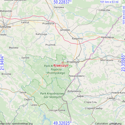
Krasiczyn GPS coordinates[2]
49° 46' 35.184" North, 22° 39' 9.072" East
| Map corner | latitude | longitude |
|---|---|---|
| Upper-left | 50.22837°, | 21.9494° |
| Center: | 49.77644°, | 22.65252° |
| Lower-right: | 49.32025°, | 23.35565° |
| Map W x H: | 101×101 km | = 62.8×62.8mi |
| max Lat: | 54.83135° ⇑92.5% North |
| Krasiczyn: | 49.77644° |
| min Lat: | ⇓7.5% South 49.21328° |
| min Long | Krasiczyn | max Long |
| 14.20249° | 22.65252° | 24.03723° |
| W 93.3%⇐ | ⇒6.7% E |
Elevation
Elevation of Krasiczyn is 215 m = 705 ft, and this is 23.6 m = 77 ft above average elevation for this country.
| Max E: |
974 m = 3196 ft | 34.7% |
| Krasiczyn | 215 m 705 ft | |
| Avg. | 191.4 m = 628 ft | |
Min E: |
-3 m = -10 ft | 65.3% |
See also: Poland elevation on elevation.city.
Geographical zone
Krasiczyn is located in North temperate zone (between Tropic of Cancer and the Arctic Circle). Distance of this North polar circle is 1866.6 km =1159.9 mi to North.| Distance of | km | miles | from Krasiczyn |
|---|---|---|---|
| North Pole | 4472.4 | 2779 | to North |
| Arctic Circle | 1866.6 | 1159.9 | to North |
| Tropic Cancer | 2928.7 | 1819.8 | to South |
| Equator | 5534.6 | 3439 | to South |


Nearby cities:
15 places around Krasiczyn: (largest is in red/bold)
• Babice
13.5 km =8.4 mi,  290°
290°
• Bircza
15.7 km =9.8 mi,  233°
233°
• Fredropol
11.2 km =7 mi,  143°
143°
• Jodłówka
18.7 km =11.6 mi,  314°
314°
• Kramarzówka
14.3 km =8.9 mi, 310°
• Krzywcza
8.1 km =5 mi, 288°
• Małkowice
15.5 km =9.6 mi,  54°
54°
• Nienadowa
17.2 km =10.7 mi, 289°
• Orły
15.1 km =9.4 mi, 45°
• Pruchnik
17.5 km =10.9 mi,  325°
325°
• Przemyśl
8.3 km =5.2 mi,  83°
83°
• Rokietnica
13.7 km =8.5 mi,  356°
356°
• Ruszelczyce
10.3 km =6.4 mi, 291°
• Węgierka
14.1 km =8.8 mi, 331°
• Żurawica
11.1 km =6.9 mi,  61°
61°
Sources, notices
• [Note1] Compared only with cities in Poland existing in our database
• [Src1] Map data: © OpenStreetMap contributors (CC-BY-SA)
• [Src2] Other city data from geonames.org with taken over terms of usage.
• [Src3] Geographical zone / Annual Mean Temperature by Robert A. Rohde @ Wikipedia
