Lesko geodata
Lesko (Subcarpathian) is a seat of a second-order administrative division; located in Poland in Europe/Warsaw (GMT+2) time zone. With population of 5,700 people, there are 628 cities with bigger population in this country. Compared to other cities in Poland, 98.8% of cities are located further ↑North; 89.4% of cities are located further ←West and 92.5% of cities have lower elevation than Lesko. Note1


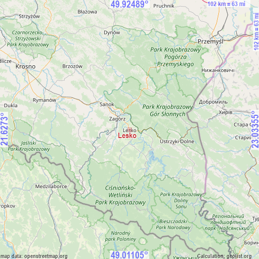
Lesko GPS coordinates[2]
49° 28' 12.36" North, 22° 19' 49.512" East
| Map corner | latitude | longitude |
|---|---|---|
| Upper-left | 49.92489°, | 21.6273° |
| Center: | 49.4701°, | 22.33042° |
| Lower-right: | 49.01105°, | 23.03355° |
| Map W x H: | 101.6×101.6 km | = 63.1×63.1mi |
| max Lat: | 54.83135° ⇑98.8% North |
| Lesko: | 49.4701° |
| min Lat: | ⇓1.2% South 49.21328° |
| min Long | Lesko | max Long |
| 14.20249° | 22.33042° | 24.03723° |
| W 89.4%⇐ | ⇒10.6% E |
Elevation
Elevation of Lesko is 362 m = 1188 ft, and this is 170.6 m = 560 ft above average elevation for this country.
| Max E: |
974 m = 3196 ft | 7.5% |
| Lesko | 362 m 1188 ft | |
| Avg. | 191.4 m = 628 ft | |
Min E: |
-3 m = -10 ft | 92.5% |
See also: Poland elevation on elevation.city.
Geographical zone
Lesko is located in North temperate zone (between Tropic of Cancer and the Arctic Circle). Distance of this North polar circle is 1900.6 km =1181 mi to North.| Distance of | km | miles | from Lesko |
|---|---|---|---|
| North Pole | 4506.5 | 2800.2 | to North |
| Arctic Circle | 1900.6 | 1181 | to North |
| Tropic Cancer | 2894.6 | 1798.6 | to South |
| Equator | 5500.6 | 3417.9 | to South |


Nearby cities:
15 places around Lesko: (largest is in red/bold)
• Baligród
15.8 km =9.8 mi,  191°
191°
• Czaszyn
8.6 km =5.3 mi,  253°
253°
• Myczkowce
6.8 km =4.2 mi,  121°
121°
• Niebieszczany
13.1 km =8.1 mi,  286°
286°
• Olszanica
8.2 km =5.1 mi,  84°
84°
• Polańczyk
12.9 km =8 mi,  149°
149°
• Poraż
7.8 km =4.8 mi,  283°
283°
• Rzepedź
19.3 km =12 mi,  234°
234°
• Sanok
13.1 km =8.1 mi,  316°
316°
• Tarnawa Dolna
5.3 km =3.3 mi, 278°
• Tarnawa Górna
5.6 km =3.5 mi,  255°
255°
• Tyrawa Wołoska
12.3 km =7.6 mi,  13°
13°
• Uherce Mineralne
4.9 km =3 mi,  97°
97°
• Zagórz
6.7 km =4.2 mi, 317°
• Łukowe
8 km =5 mi, 233°
Sources, notices
• [Note1] Compared only with cities in Poland existing in our database
• [Src1] Map data: © OpenStreetMap contributors (CC-BY-SA)
• [Src2] Other city data from geonames.org with taken over terms of usage.
• [Src3] Geographical zone / Annual Mean Temperature by Robert A. Rohde @ Wikipedia
