Niebieszczany geodata
Niebieszczany (Subcarpathian) is a populated place; located in Poland in Europe/Warsaw (GMT+2) time zone. With population of 2,500 people, there are 1240 cities with bigger population in this country. Compared to other cities in Poland, 98.2% of cities are located further ↑North; 86.9% of cities are located further ←West and 92.2% of cities have lower elevation than Niebieszczany. Note1


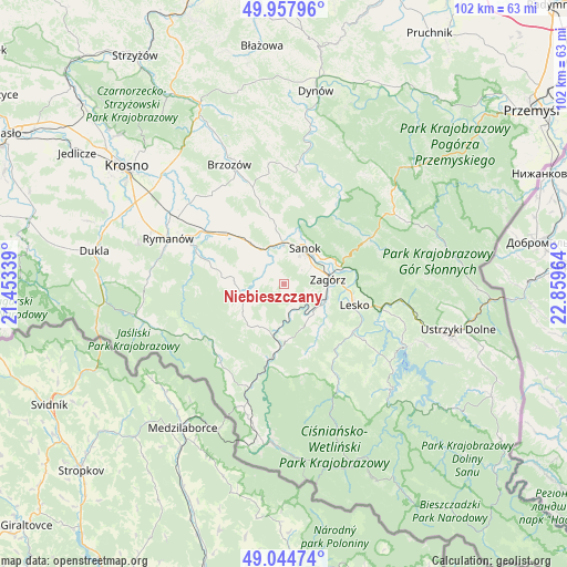
Niebieszczany GPS coordinates[2]
49° 30' 12.528" North, 22° 9' 23.436" East
| Map corner | latitude | longitude |
|---|---|---|
| Upper-left | 49.95796°, | 21.45339° |
| Center: | 49.50348°, | 22.15651° |
| Lower-right: | 49.04474°, | 22.85964° |
| Map W x H: | 101.5×101.5 km | = 63.1×63.1mi |
| max Lat: | 54.83135° ⇑98.2% North |
| Niebieszczany: | 49.50348° |
| min Lat: | ⇓1.8% South 49.21328° |
| min Long | Niebieszczany | max Long |
| 14.20249° | 22.15651° | 24.03723° |
| W 86.9%⇐ | ⇒13.1% E |
Elevation
Elevation of Niebieszczany is 360 m = 1181 ft, and this is 168.6 m = 553 ft above average elevation for this country.
| Max E: |
974 m = 3196 ft | 7.8% |
| Niebieszczany | 360 m 1181 ft | |
| Avg. | 191.4 m = 628 ft | |
Min E: |
-3 m = -10 ft | 92.2% |
See also: Poland elevation on elevation.city.
Geographical zone
Niebieszczany is located in North temperate zone (between Tropic of Cancer and the Arctic Circle). Distance of this North polar circle is 1896.9 km =1178.7 mi to North.| Distance of | km | miles | from Niebieszczany |
|---|---|---|---|
| North Pole | 4502.8 | 2797.9 | to North |
| Arctic Circle | 1896.9 | 1178.7 | to North |
| Tropic Cancer | 2898.4 | 1801 | to South |
| Equator | 5504.3 | 3420.2 | to South |


Nearby cities:
15 places around Niebieszczany: (largest is in red/bold)
• Bukowsko
7.2 km =4.5 mi,  249°
249°
• Czaszyn
7.5 km =4.7 mi,  144°
144°
• Długie
11.7 km =7.3 mi,  315°
315°
• Kostarowce
9.6 km =6 mi,  341°
341°
• Lesko
13.1 km =8.1 mi,  106°
106°
• Nowosielce-Gniewosz
9.6 km =6 mi, 318°
• Pielnia
8.4 km =5.2 mi,  297°
297°
• Pisarowce
7.5 km =4.7 mi, 324°
• Poraż
5.3 km =3.3 mi, 111°
• Sanok
6.8 km =4.2 mi,  31°
31°
• Strachocina
12.6 km =7.8 mi, 337°
• Tarnawa Dolna
7.9 km =4.9 mi, 111°
• Tarnawa Górna
8.8 km =5.5 mi,  125°
125°
• Zagórz
8.1 km =5 mi,  81°
81°
• Łukowe
10.4 km =6.5 mi, 144°
Sources, notices
• [Note1] Compared only with cities in Poland existing in our database
• [Src1] Map data: © OpenStreetMap contributors (CC-BY-SA)
• [Src2] Other city data from geonames.org with taken over terms of usage.
• [Src3] Geographical zone / Annual Mean Temperature by Robert A. Rohde @ Wikipedia
