Sanok geodata
Sanok (Subcarpathian) is a seat of a second-order administrative division; located in Poland in Europe/Warsaw (GMT+2) time zone. With population of 39,684 people, there are 130 cities with bigger population in this country. Compared to other cities in Poland, 97.5% of cities are located further ↑North; 87.4% of cities are located further ←West and 85% of cities have lower elevation than Sanok. Note1


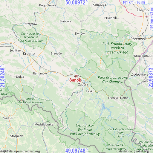
Sanok GPS coordinates[2]
49° 33' 20.628" North, 22° 12' 20.16" East
| Map corner | latitude | longitude |
|---|---|---|
| Upper-left | 50.00972°, | 21.50248° |
| Center: | 49.55573°, | 22.2056° |
| Lower-right: | 49.09748°, | 22.90873° |
| Map W x H: | 101.4×101.4 km | = 63×63mi |
| max Lat: | 54.83135° ⇑97.5% North |
| Sanok: | 49.55573° |
| min Lat: | ⇓2.5% South 49.21328° |
| min Long | Sanok | max Long |
| 14.20249° | 22.2056° | 24.03723° |
| W 87.4%⇐ | ⇒12.6% E |
Elevation
Elevation of Sanok is 289 m = 948 ft, and this is 97.6 m = 320 ft above average elevation for this country.
| Max E: |
974 m = 3196 ft | 15% |
| Sanok | 289 m 948 ft | |
| Avg. | 191.4 m = 628 ft | |
Min E: |
-3 m = -10 ft | 85% |
See also: Poland elevation on elevation.city.
Geographical zone
Sanok is located in North temperate zone (between Tropic of Cancer and the Arctic Circle). Distance of this North polar circle is 1891.1 km =1175.1 mi to North.| Distance of | km | miles | from Sanok |
|---|---|---|---|
| North Pole | 4497 | 2794.3 | to North |
| Arctic Circle | 1891.1 | 1175.1 | to North |
| Tropic Cancer | 2904.2 | 1804.6 | to South |
| Equator | 5510.1 | 3423.8 | to South |


Nearby cities:
15 places around Sanok: (largest is in red/bold)
• Czaszyn
11.9 km =7.4 mi,  176°
176°
• Długie
12 km =7.5 mi,  282°
282°
• Kostarowce
7.4 km =4.6 mi,  296°
296°
• Lesko
13.1 km =8.1 mi,  136°
136°
• Niebieszczany
6.8 km =4.2 mi,  211°
211°
• Nowosielce-Gniewosz
9.9 km =6.2 mi, 278°
• Pakoszówka
10.4 km =6.5 mi,  315°
315°
• Pielnia
11.2 km =7 mi,  259°
259°
• Pisarowce
7.9 km =4.9 mi,  272°
272°
• Poraż
7.9 km =4.9 mi,  169°
169°
• Strachocina
10.3 km =6.4 mi, 304°
• Tarnawa Dolna
9.5 km =5.9 mi,  156°
156°
• Tarnawa Górna
11.5 km =7.1 mi, 161°
• Tyrawa Wołoska
12.1 km =7.5 mi,  78°
78°
• Zagórz
6.4 km =4 mi, 135°
Sources, notices
• [Note1] Compared only with cities in Poland existing in our database
• [Src1] Map data: © OpenStreetMap contributors (CC-BY-SA)
• [Src2] Other city data from geonames.org with taken over terms of usage.
• [Src3] Geographical zone / Annual Mean Temperature by Robert A. Rohde @ Wikipedia
