Książnice geodata
Książnice (Lesser Poland) is a populated place; located in Poland in Europe/Warsaw (GMT+2) time zone. With population of 736 people, there are 2996 cities with bigger population in this country. Compared to other cities in Poland, 85.5% of cities are located further ↑North; 62.5% of cities are located further ←West and 64.1% of cities have lower elevation than Książnice. Note1


Książnice GPS coordinates[2]
49° 57' 1.62" North, 20° 17' 42.036" East
| Map corner | latitude | longitude |
|---|---|---|
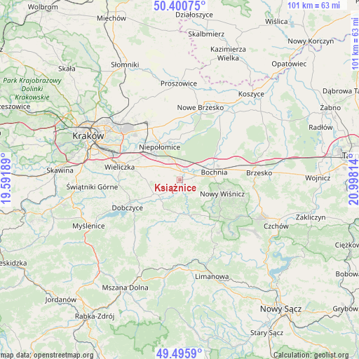
| Upper-left | 50.40075°, | 19.59189° |
| Center: | 49.95045°, | 20.29501° |
| Lower-right: | 49.4959°, | 20.99814° |
| Map W x H: | 100.6×100.6 km | = 62.5×62.5mi |
| max Lat: | 54.83135° ⇑85.5% North |
| Książnice: | 49.95045° |
| min Lat: | ⇓14.5% South 49.21328° |
| min Long | Książnice | max Long |
| 14.20249° | 20.29501° | 24.03723° |
| W 62.5%⇐ | ⇒37.5% E |
Elevation
Elevation of Książnice is 212 m = 696 ft, and this is 20.6 m = 68 ft above average elevation for this country.
| Max E: |
974 m = 3196 ft | 35.9% |
| Książnice | 212 m 696 ft | |
| Avg. | 191.4 m = 628 ft | |
Min E: |
-3 m = -10 ft | 64.1% |
See also: Poland elevation on elevation.city.
Geographical zone
Książnice is located in North temperate zone (between Tropic of Cancer and the Arctic Circle). Distance of this North polar circle is 1847.2 km =1147.8 mi to North.| Distance of | km | miles | from Książnice |
|---|---|---|---|
| North Pole | 4453.1 | 2767 | to North |
| Arctic Circle | 1847.2 | 1147.8 | to North |
| Tropic Cancer | 2948.1 | 1831.9 | to South |
| Equator | 5554 | 3451.1 | to South |


Nearby cities:
15 places around Książnice: (largest is in red/bold)
• Cichawa
2 km =1.2 mi,  272°
272°
• Damienice
8.6 km =5.3 mi,  57°
57°
• Dąbrowa
6.9 km =4.3 mi,  334°
334°
• Gdów
8.3 km =5.2 mi,  235°
235°
• Gierczyce
3.5 km =2.2 mi,  91°
91°
• Kłaj
4.7 km =2.9 mi,  3°
3°
• Marszowice
5.6 km =3.5 mi,  228°
228°
• Pierzchów
2 km =1.2 mi,  210°
210°
• Siedlec
1.8 km =1.1 mi,  76°
76°
• Stanisławice
5.6 km =3.5 mi,  45°
45°
• Szarów
5.3 km =3.3 mi,  339°
339°
• Szczytniki
5.4 km =3.4 mi,  299°
299°
• Targowisko
3.8 km =2.4 mi,  358°
358°
• Zręczyce
9 km =5.6 mi,  218°
218°
• Łapczyca
6.5 km =4 mi, 80°
Sources, notices
• [Note1] Compared only with cities in Poland existing in our database
• [Src1] Map data: © OpenStreetMap contributors (CC-BY-SA)
• [Src2] Other city data from geonames.org with taken over terms of usage.
• [Src3] Geographical zone / Annual Mean Temperature by Robert A. Rohde @ Wikipedia
