Gdów geodata
Gdów (Lesser Poland) is a seat of a third-order administrative division; located in Poland in Europe/Warsaw (GMT+2) time zone. With population of 4,500 people, there are 730 cities with bigger population in this country. Compared to other cities in Poland, 87.1% of cities are located further ↑North; 61.2% of cities are located further ←West and 69.6% of cities have lower elevation than Gdów. Note1


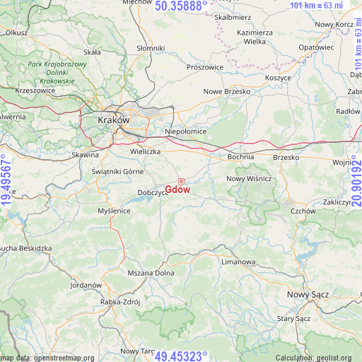
Gdów GPS coordinates[2]
49° 54' 29.448" North, 20° 11' 55.644" East
| Map corner | latitude | longitude |
|---|---|---|
| Upper-left | 50.35888°, | 19.49567° |
| Center: | 49.90818°, | 20.19879° |
| Lower-right: | 49.45323°, | 20.90192° |
| Map W x H: | 100.7×100.7 km | = 62.6×62.6mi |
| max Lat: | 54.83135° ⇑87.1% North |
| Gdów: | 49.90818° |
| min Lat: | ⇓12.9% South 49.21328° |
| min Long | Gdów | max Long |
| 14.20249° | 20.19879° | 24.03723° |
| W 61.2%⇐ | ⇒38.8% E |
Elevation
Elevation of Gdów is 228 m = 748 ft, and this is 36.6 m = 120 ft above average elevation for this country.
| Max E: |
974 m = 3196 ft | 30.4% |
| Gdów | 228 m 748 ft | |
| Avg. | 191.4 m = 628 ft | |
Min E: |
-3 m = -10 ft | 69.6% |
See also: Poland elevation on elevation.city.
Geographical zone
Gdów is located in North temperate zone (between Tropic of Cancer and the Arctic Circle). Distance of this North polar circle is 1851.9 km =1150.7 mi to North.| Distance of | km | miles | from Gdów |
|---|---|---|---|
| North Pole | 4457.8 | 2769.9 | to North |
| Arctic Circle | 1851.9 | 1150.7 | to North |
| Tropic Cancer | 2943.4 | 1828.9 | to South |
| Equator | 5549.3 | 3448.2 | to South |


Nearby cities:
15 places around Gdów: (largest is in red/bold)
• Biskupice
8.3 km =5.2 mi,  318°
318°
• Cichawa
6.9 km =4.3 mi,  45°
45°
• Dobczyce
8.4 km =5.2 mi,  248°
248°
• Kornatka
10.4 km =6.5 mi,  231°
231°
• Krasne-Lasocice
10.8 km =6.7 mi,  168°
168°
• Książnice
8.3 km =5.2 mi,  55°
55°
• Marszowice
2.9 km =1.8 mi,  69°
69°
• Pierzchów
6.6 km =4.1 mi, 63°
• Raciechowice
8.1 km =5 mi,  209°
209°
• Siedlec
10 km =6.2 mi, 59°
• Szczytniki
7.7 km =4.8 mi,  16°
16°
• Tomaszkowice
10.6 km =6.6 mi, 318°
• Trąbki
7.2 km =4.5 mi,  326°
326°
• Zręczyce
2.7 km =1.7 mi,  149°
149°
• Łapanów
8.2 km =5.1 mi,  125°
125°
Sources, notices
• [Note1] Compared only with cities in Poland existing in our database
• [Src1] Map data: © OpenStreetMap contributors (CC-BY-SA)
• [Src2] Other city data from geonames.org with taken over terms of usage.
• [Src3] Geographical zone / Annual Mean Temperature by Robert A. Rohde @ Wikipedia
