Dąbrowa geodata
Dąbrowa (Lesser Poland) is a populated place; located in Poland in Europe/Warsaw (GMT+2) time zone. With population of 990 people, there are 2509 cities with bigger population in this country. Compared to other cities in Poland, 82.2% of cities are located further ↑North; 61.9% of cities are located further ←West and 69.1% of cities have lower elevation than Dąbrowa. Note1


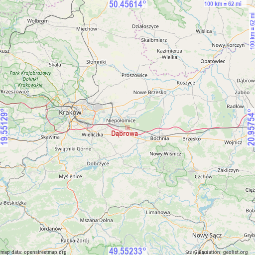
Dąbrowa GPS coordinates[2]
50° 0' 22.896" North, 20° 15' 15.876" East
| Map corner | latitude | longitude |
|---|---|---|
| Upper-left | 50.45614°, | 19.55129° |
| Center: | 50.00636°, | 20.25441° |
| Lower-right: | 49.55233°, | 20.95754° |
| Map W x H: | 100.5×100.5 km | = 62.4×62.4mi |
| max Lat: | 54.83135° ⇑82.2% North |
| Dąbrowa: | 50.00636° |
| min Lat: | ⇓17.8% South 49.21328° |
| min Long | Dąbrowa | max Long |
| 14.20249° | 20.25441° | 24.03723° |
| W 61.9%⇐ | ⇒38.1% E |
Elevation
Elevation of Dąbrowa is 226 m = 741 ft, and this is 34.6 m = 114 ft above average elevation for this country.
| Max E: |
974 m = 3196 ft | 30.9% |
| Dąbrowa | 226 m 741 ft | |
| Avg. | 191.4 m = 628 ft | |
Min E: |
-3 m = -10 ft | 69.1% |
See also: Poland elevation on elevation.city.
Geographical zone
Dąbrowa is located in North temperate zone (between Tropic of Cancer and the Arctic Circle). Distance of this North polar circle is 1841 km =1143.9 mi to North.| Distance of | km | miles | from Dąbrowa |
|---|---|---|---|
| North Pole | 4446.9 | 2763.2 | to North |
| Arctic Circle | 1841 | 1143.9 | to North |
| Tropic Cancer | 2954.3 | 1835.7 | to South |
| Equator | 5560.2 | 3454.9 | to South |


Nearby cities:
15 places around Dąbrowa: (largest is in red/bold)
• Cichawa
6.2 km =3.9 mi,  171°
171°
• Gierczyce
9 km =5.6 mi,  134°
134°
• Książnice
6.9 km =4.3 mi,  154°
154°
• Kłaj
3.5 km =2.2 mi,  115°
115°
• Niepołomice
4.4 km =2.7 mi,  329°
329°
• Pierzchów
8.2 km =5.1 mi, 166°
• Podłęże
6.3 km =3.9 mi,  278°
278°
• Siedlec
7.4 km =4.6 mi,  141°
141°
• Stanisławice
7.3 km =4.5 mi,  108°
108°
• Szarów
1.7 km =1.1 mi, 139°
• Szczytniki
4 km =2.5 mi,  206°
206°
• Targowisko
3.7 km =2.3 mi, 130°
• Wola Batorska
5.2 km =3.2 mi,  9°
9°
• Wola Zabierzowska
9.2 km =5.7 mi,  37°
37°
• Zabierzów Bocheński
8.3 km =5.2 mi,  33°
33°
Sources, notices
• [Note1] Compared only with cities in Poland existing in our database
• [Src1] Map data: © OpenStreetMap contributors (CC-BY-SA)
• [Src2] Other city data from geonames.org with taken over terms of usage.
• [Src3] Geographical zone / Annual Mean Temperature by Robert A. Rohde @ Wikipedia
