Pierzchów geodata
Pierzchów (Lesser Poland) is a populated place; located in Poland in Europe/Warsaw (GMT+2) time zone. With population of 560 people, there are 3377 cities with bigger population in this country. Compared to other cities in Poland, 86.3% of cities are located further ↑North; 62.2% of cities are located further ←West and 64.5% of cities have lower elevation than Pierzchów. Note1


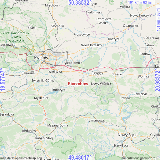
Pierzchów GPS coordinates[2]
49° 56' 5.532" North, 20° 16' 50.124" East
| Map corner | latitude | longitude |
|---|---|---|
| Upper-left | 50.38532°, | 19.57747° |
| Center: | 49.93487°, | 20.28059° |
| Lower-right: | 49.48017°, | 20.98372° |
| Map W x H: | 100.6×100.6 km | = 62.5×62.5mi |
| max Lat: | 54.83135° ⇑86.3% North |
| Pierzchów: | 49.93487° |
| min Lat: | ⇓13.7% South 49.21328° |
| min Long | Pierzchów | max Long |
| 14.20249° | 20.28059° | 24.03723° |
| W 62.2%⇐ | ⇒37.8% E |
Elevation
Elevation of Pierzchów is 213 m = 699 ft, and this is 21.6 m = 71 ft above average elevation for this country.
| Max E: |
974 m = 3196 ft | 35.5% |
| Pierzchów | 213 m 699 ft | |
| Avg. | 191.4 m = 628 ft | |
Min E: |
-3 m = -10 ft | 64.5% |
See also: Poland elevation on elevation.city.
Geographical zone
Pierzchów is located in North temperate zone (between Tropic of Cancer and the Arctic Circle). Distance of this North polar circle is 1848.9 km =1148.9 mi to North.| Distance of | km | miles | from Pierzchów |
|---|---|---|---|
| North Pole | 4454.8 | 2768.1 | to North |
| Arctic Circle | 1848.9 | 1148.9 | to North |
| Tropic Cancer | 2946.3 | 1830.7 | to South |
| Equator | 5552.2 | 3450 | to South |


Nearby cities:
15 places around Pierzchów: (largest is in red/bold)
• Cichawa
2 km =1.2 mi,  332°
332°
• Dąbrowa
8.2 km =5.1 mi,  346°
346°
• Gdów
6.6 km =4.1 mi,  243°
243°
• Gierczyce
4.8 km =3 mi,  70°
70°
• Książnice
2 km =1.2 mi,  30°
30°
• Kłaj
6.5 km =4 mi,  11°
11°
• Marszowice
3.7 km =2.3 mi, 238°
• Siedlec
3.5 km =2.2 mi,  52°
52°
• Stanisławice
7.6 km =4.7 mi,  41°
41°
• Szarów
6.7 km =4.2 mi, 353°
• Szczytniki
5.7 km =3.5 mi,  320°
320°
• Targowisko
5.6 km =3.5 mi, 9°
• Zręczyce
7 km =4.3 mi,  220°
220°
• Łapanów
7.8 km =4.8 mi,  174°
174°
• Łapczyca
7.9 km =4.9 mi, 69°
Sources, notices
• [Note1] Compared only with cities in Poland existing in our database
• [Src1] Map data: © OpenStreetMap contributors (CC-BY-SA)
• [Src2] Other city data from geonames.org with taken over terms of usage.
• [Src3] Geographical zone / Annual Mean Temperature by Robert A. Rohde @ Wikipedia
