Kłaj geodata
Kłaj (Lesser Poland) is a seat of a third-order administrative division; located in Poland in Europe/Warsaw (GMT+2) time zone. With population of 3,500 people, there are 911 cities with bigger population in this country. Compared to other cities in Poland, 82.9% of cities are located further ↑North; 62.6% of cities are located further ←West and 63.8% of cities have lower elevation than Kłaj. Note1


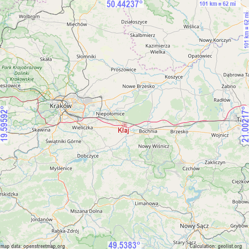
Kłaj GPS coordinates[2]
49° 59' 32.856" North, 20° 17' 56.544" East
| Map corner | latitude | longitude |
|---|---|---|
| Upper-left | 50.44237°, | 19.59592° |
| Center: | 49.99246°, | 20.29904° |
| Lower-right: | 49.5383°, | 21.00217° |
| Map W x H: | 100.5×100.5 km | = 62.4×62.4mi |
| max Lat: | 54.83135° ⇑82.9% North |
| Kłaj: | 49.99246° |
| min Lat: | ⇓17.1% South 49.21328° |
| min Long | Kłaj | max Long |
| 14.20249° | 20.29904° | 24.03723° |
| W 62.6%⇐ | ⇒37.4% E |
Elevation
Elevation of Kłaj is 211 m = 692 ft, and this is 19.6 m = 64 ft above average elevation for this country.
| Max E: |
974 m = 3196 ft | 36.2% |
| Kłaj | 211 m 692 ft | |
| Avg. | 191.4 m = 628 ft | |
Min E: |
-3 m = -10 ft | 63.8% |
See also: Poland elevation on elevation.city.
Geographical zone
Kłaj is located in North temperate zone (between Tropic of Cancer and the Arctic Circle). Distance of this North polar circle is 1842.5 km =1144.9 mi to North.| Distance of | km | miles | from Kłaj |
|---|---|---|---|
| North Pole | 4448.4 | 2764.1 | to North |
| Arctic Circle | 1842.5 | 1144.9 | to North |
| Tropic Cancer | 2952.7 | 1834.7 | to South |
| Equator | 5558.6 | 3454 | to South |


Nearby cities:
15 places around Kłaj: (largest is in red/bold)
• Cichawa
5.1 km =3.2 mi,  206°
206°
• Damienice
7 km =4.3 mi,  90°
90°
• Dąbrowa
3.5 km =2.2 mi,  295°
295°
• Gierczyce
5.8 km =3.6 mi,  146°
146°
• Książnice
4.7 km =2.9 mi,  183°
183°
• Niepołomice
7.7 km =4.8 mi,  314°
314°
• Pierzchów
6.5 km =4 mi,  191°
191°
• Siedlec
4.5 km =2.8 mi,  161°
161°
• Stanisławice
3.8 km =2.4 mi,  101°
101°
• Szarów
2.1 km =1.3 mi,  277°
277°
• Szczytniki
5.3 km =3.3 mi,  247°
247°
• Targowisko
0.9 km =0.6 mi,  204°
204°
• Wola Batorska
7.1 km =4.4 mi,  340°
340°
• Zabierzów Bocheński
8.5 km =5.3 mi,  9°
9°
• Łapczyca
7.1 km =4.4 mi,  120°
120°
Sources, notices
• [Note1] Compared only with cities in Poland existing in our database
• [Src1] Map data: © OpenStreetMap contributors (CC-BY-SA)
• [Src2] Other city data from geonames.org with taken over terms of usage.
• [Src3] Geographical zone / Annual Mean Temperature by Robert A. Rohde @ Wikipedia
