Krynice geodata
Krynice (Lublin) is a seat of a third-order administrative division; located in Poland in Europe/Warsaw (GMT+2) time zone. With population of 567 people, there are 3366 cities with bigger population in this country. Compared to other cities in Poland, 65.4% of cities are located further ↑North; 98.4% of cities are located further ←West and 80.9% of cities have lower elevation than Krynice. Note1


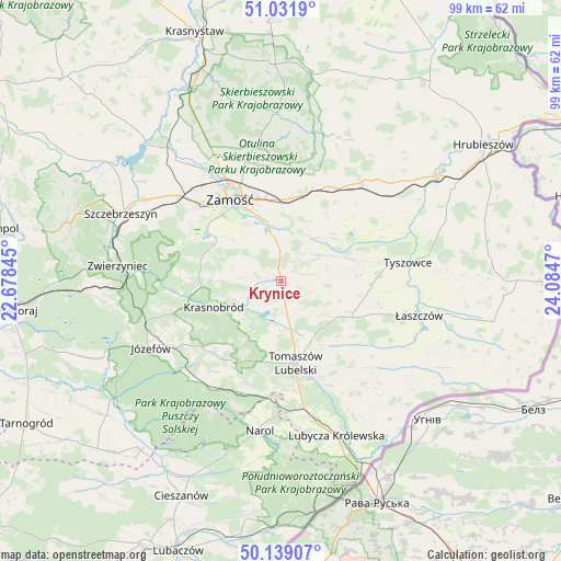
Krynice GPS coordinates[2]
50° 35' 15.36" North, 23° 22' 53.652" East
| Map corner | latitude | longitude |
|---|---|---|
| Upper-left | 51.0319°, | 22.67845° |
| Center: | 50.5876°, | 23.38157° |
| Lower-right: | 50.13907°, | 24.0847° |
| Map W x H: | 99.3×99.3 km | = 61.7×61.7mi |
| max Lat: | 54.83135° ⇑65.4% North |
| Krynice: | 50.5876° |
| min Lat: | ⇓34.6% South 49.21328° |
| min Long | Krynice | max Long |
| 14.20249° | 23.38157° | 24.03723° |
| W 98.4%⇐ | ⇒1.6% E |
Elevation
Elevation of Krynice is 269 m = 883 ft, and this is 77.6 m = 255 ft above average elevation for this country.
| Max E: |
974 m = 3196 ft | 19.1% |
| Krynice | 269 m 883 ft | |
| Avg. | 191.4 m = 628 ft | |
Min E: |
-3 m = -10 ft | 80.9% |
See also: Poland elevation on elevation.city.
Geographical zone
Krynice is located in North temperate zone (between Tropic of Cancer and the Arctic Circle). Distance of this North polar circle is 1776.4 km =1103.8 mi to North.| Distance of | km | miles | from Krynice |
|---|---|---|---|
| North Pole | 4382.2 | 2723 | to North |
| Arctic Circle | 1776.4 | 1103.8 | to North |
| Tropic Cancer | 3018.9 | 1875.9 | to South |
| Equator | 5624.8 | 3495.1 | to South |


Nearby cities:
15 places around Krynice: (largest is in red/bold)
• Komarów-Osada
8.2 km =5.1 mi,  55°
55°
• Krasnobród
12.8 km =8 mi,  248°
248°
• Michałów
16.3 km =10.1 mi,  106°
106°
• Miączyn
18.8 km =11.7 mi,  26°
26°
• Rachanie
12.9 km =8 mi,  115°
115°
• Rogóźno
13.7 km =8.5 mi,  177°
177°
• Sitno
18 km =11.2 mi,  355°
355°
• Stanisławów
19.2 km =11.9 mi,  243°
243°
• Susiec
22.8 km =14.2 mi,  215°
215°
• Tarnawatka
6.3 km =3.9 mi,  170°
170°
• Tomaszów Lubelski
15.7 km =9.8 mi, 171°
• Tyszowce
22.7 km =14.1 mi,  81°
81°
• Wysokie
21.6 km =13.4 mi,  328°
328°
• Zamość
17.6 km =10.9 mi, 328°
• Łabunie
7.6 km =4.7 mi,  351°
351°
Sources, notices
• [Note1] Compared only with cities in Poland existing in our database
• [Src1] Map data: © OpenStreetMap contributors (CC-BY-SA)
• [Src2] Other city data from geonames.org with taken over terms of usage.
• [Src3] Geographical zone / Annual Mean Temperature by Robert A. Rohde @ Wikipedia
