Rachanie geodata
Rachanie (Lublin) is a seat of a third-order administrative division; located in Poland in Europe/Warsaw (GMT+2) time zone. With population of 990 people, there are 2509 cities with bigger population in this country. Compared to other cities in Poland, 66.5% of cities are located further ↑North; 98.9% of cities are located further ←West and 69.1% of cities have lower elevation than Rachanie. Note1


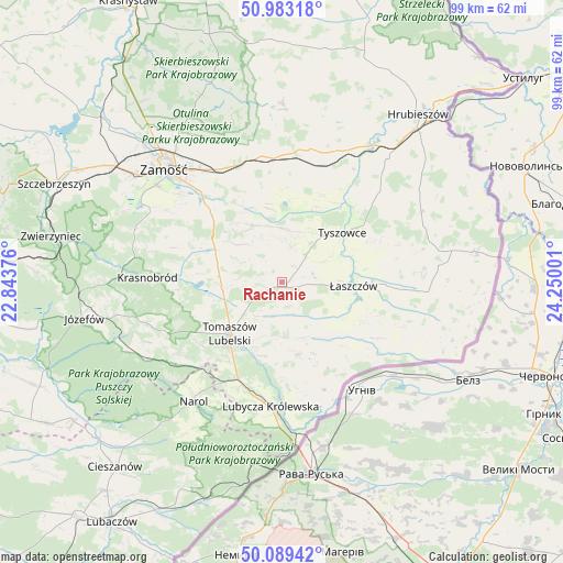
Rachanie GPS coordinates[2]
50° 32' 18.312" North, 23° 32' 48.768" East
| Map corner | latitude | longitude |
|---|---|---|
| Upper-left | 50.98318°, | 22.84376° |
| Center: | 50.53842°, | 23.54688° |
| Lower-right: | 50.08942°, | 24.25001° |
| Map W x H: | 99.4×99.4 km | = 61.8×61.8mi |
| max Lat: | 54.83135° ⇑66.5% North |
| Rachanie: | 50.53842° |
| min Lat: | ⇓33.5% South 49.21328° |
| min Long | Rachanie | max Long |
| 14.20249° | 23.54688° | 24.03723° |
| W 98.9%⇐ | ⇒1.1% E |
Elevation
Elevation of Rachanie is 226 m = 741 ft, and this is 34.6 m = 114 ft above average elevation for this country.
| Max E: |
974 m = 3196 ft | 30.9% |
| Rachanie | 226 m 741 ft | |
| Avg. | 191.4 m = 628 ft | |
Min E: |
-3 m = -10 ft | 69.1% |
See also: Poland elevation on elevation.city.
Geographical zone
Rachanie is located in North temperate zone (between Tropic of Cancer and the Arctic Circle). Distance of this North polar circle is 1781.8 km =1107.2 mi to North.| Distance of | km | miles | from Rachanie |
|---|---|---|---|
| North Pole | 4387.7 | 2726.4 | to North |
| Arctic Circle | 1781.8 | 1107.2 | to North |
| Tropic Cancer | 3013.4 | 1872.4 | to South |
| Equator | 5619.3 | 3491.7 | to South |


Nearby cities:
15 places around Rachanie: (largest is in red/bold)
• Bełżec
18.8 km =11.7 mi,  204°
204°
• Jarczów
13 km =8.1 mi,  167°
167°
• Komarów-Osada
11.2 km =7 mi,  334°
334°
• Krynice
12.9 km =8 mi,  295°
295°
• Lubycza Królewska
22 km =13.7 mi,  185°
185°
• Michałów
4.1 km =2.5 mi,  76°
76°
• Miączyn
22.5 km =14 mi,  351°
351°
• Rogóźno
13.8 km =8.6 mi,  233°
233°
• Tarnawatka
10.7 km =6.6 mi,  265°
265°
• Telatyn
20.7 km =12.9 mi,  93°
93°
• Tomaszów Lubelski
13.7 km =8.5 mi,  222°
222°
• Tyszowce
13.9 km =8.6 mi,  50°
50°
• Ulhówek
20.4 km =12.7 mi,  118°
118°
• Łabunie
18.2 km =11.3 mi,  315°
315°
• Łaszczów
12.6 km =7.8 mi, 92°
Sources, notices
• [Note1] Compared only with cities in Poland existing in our database
• [Src1] Map data: © OpenStreetMap contributors (CC-BY-SA)
• [Src2] Other city data from geonames.org with taken over terms of usage.
• [Src3] Geographical zone / Annual Mean Temperature by Robert A. Rohde @ Wikipedia
