Wysokie geodata
Wysokie (Lublin) is a populated place; located in Poland in Europe/Warsaw (GMT+2) time zone. With population of 673 people, there are 3123 cities with bigger population in this country. Compared to other cities in Poland, 61.3% of cities are located further ↑North; 97.6% of cities are located further ←West and 62.4% of cities have lower elevation than Wysokie. Note1


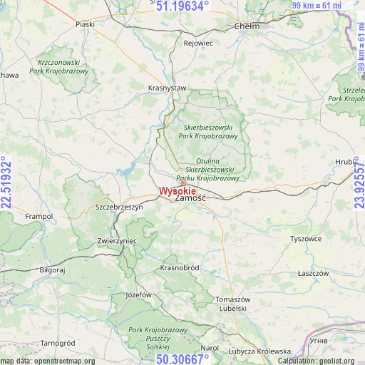
Wysokie GPS coordinates[2]
50° 45' 13.032" North, 23° 13' 20.784" East
| Map corner | latitude | longitude |
|---|---|---|
| Upper-left | 51.19634°, | 22.51932° |
| Center: | 50.75362°, | 23.22244° |
| Lower-right: | 50.30667°, | 23.92557° |
| Map W x H: | 98.9×98.9 km | = 61.5×61.5mi |
| max Lat: | 54.83135° ⇑61.3% North |
| Wysokie: | 50.75362° |
| min Lat: | ⇓38.7% South 49.21328° |
| min Long | Wysokie | max Long |
| 14.20249° | 23.22244° | 24.03723° |
| W 97.6%⇐ | ⇒2.4% E |
Elevation
Elevation of Wysokie is 207 m = 679 ft, and this is 15.6 m = 51 ft above average elevation for this country.
| Max E: |
974 m = 3196 ft | 37.6% |
| Wysokie | 207 m 679 ft | |
| Avg. | 191.4 m = 628 ft | |
Min E: |
-3 m = -10 ft | 62.4% |
See also: Poland elevation on elevation.city.
Geographical zone
Wysokie is located in North temperate zone (between Tropic of Cancer and the Arctic Circle). Distance of this North polar circle is 1757.9 km =1092.3 mi to North.| Distance of | km | miles | from Wysokie |
|---|---|---|---|
| North Pole | 4363.8 | 2711.5 | to North |
| Arctic Circle | 1757.9 | 1092.3 | to North |
| Tropic Cancer | 3037.4 | 1887.4 | to South |
| Equator | 5643.3 | 3506.6 | to South |


Nearby cities:
15 places around Wysokie: (largest is in red/bold)
• Dębowiec
9.2 km =5.7 mi,  57°
57°
• Izbica
15.7 km =9.8 mi,  341°
341°
• Kawęczyn
21.3 km =13.2 mi,  245°
245°
• Krasne
12.7 km =7.9 mi, 343°
• Krynice
21.6 km =13.4 mi,  148°
148°
• Michałów
14.2 km =8.8 mi,  262°
262°
• Miączyn
19.7 km =12.2 mi,  94°
94°
• Nielisz
13.6 km =8.5 mi,  292°
292°
• Sitno
9.9 km =6.2 mi, 92°
• Skierbieszów
14.5 km =9 mi,  41°
41°
• Stary Zamość
8.2 km =5.1 mi,  334°
334°
• Sułów
18.8 km =11.7 mi,  275°
275°
• Szczebrzeszyn
18.3 km =11.4 mi, 249°
• Zamość
4 km =2.5 mi, 148°
• Łabunie
14.9 km =9.3 mi,  137°
137°
Sources, notices
• [Note1] Compared only with cities in Poland existing in our database
• [Src1] Map data: © OpenStreetMap contributors (CC-BY-SA)
• [Src2] Other city data from geonames.org with taken over terms of usage.
• [Src3] Geographical zone / Annual Mean Temperature by Robert A. Rohde @ Wikipedia
