Rogóźno geodata
Rogóźno (Lublin) is a populated place; located in Poland in Europe/Warsaw (GMT+2) time zone. With population of 1,153 people, there are 2253 cities with bigger population in this country. Compared to other cities in Poland, 67.9% of cities are located further ↑North; 98.4% of cities are located further ←West and 81.4% of cities have lower elevation than Rogóźno. Note1


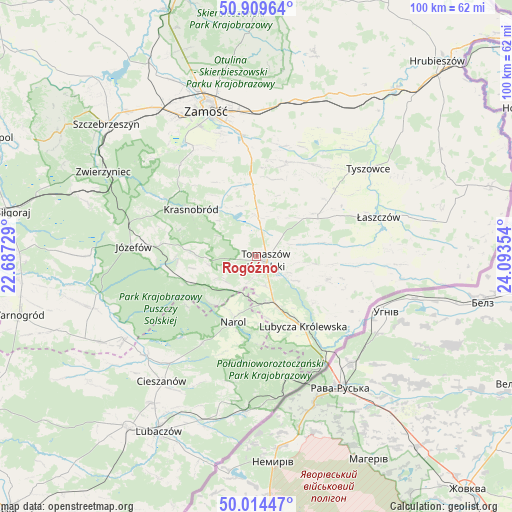
Rogóźno GPS coordinates[2]
50° 27' 51.012" North, 23° 23' 25.476" East
| Map corner | latitude | longitude |
|---|---|---|
| Upper-left | 50.90964°, | 22.68729° |
| Center: | 50.46417°, | 23.39041° |
| Lower-right: | 50.01447°, | 24.09354° |
| Map W x H: | 99.5×99.5 km | = 61.8×61.8mi |
| max Lat: | 54.83135° ⇑67.9% North |
| Rogóźno: | 50.46417° |
| min Lat: | ⇓32.1% South 49.21328° |
| min Long | Rogóźno | max Long |
| 14.20249° | 23.39041° | 24.03723° |
| W 98.4%⇐ | ⇒1.6% E |
Elevation
Elevation of Rogóźno is 273 m = 896 ft, and this is 81.6 m = 268 ft above average elevation for this country.
| Max E: |
974 m = 3196 ft | 18.6% |
| Rogóźno | 273 m 896 ft | |
| Avg. | 191.4 m = 628 ft | |
Min E: |
-3 m = -10 ft | 81.4% |
See also: Poland elevation on elevation.city.
Geographical zone
Rogóźno is located in North temperate zone (between Tropic of Cancer and the Arctic Circle). Distance of this North polar circle is 1790.1 km =1112.3 mi to North.| Distance of | km | miles | from Rogóźno |
|---|---|---|---|
| North Pole | 4396 | 2731.5 | to North |
| Arctic Circle | 1790.1 | 1112.3 | to North |
| Tropic Cancer | 3005.2 | 1867.3 | to South |
| Equator | 5611.1 | 3486.6 | to South |


Nearby cities:
15 places around Rogóźno: (largest is in red/bold)
• Bełżec
9.5 km =5.9 mi,  159°
159°
• Jarczów
14.5 km =9 mi,  107°
107°
• Komarów-Osada
19.3 km =12 mi,  18°
18°
• Krasnobród
15.5 km =9.6 mi,  305°
305°
• Krynice
13.7 km =8.5 mi,  357°
357°
• Lubycza Królewska
16.5 km =10.3 mi,  146°
146°
• Michałów
17.7 km =11 mi,  58°
58°
• Narol
13.5 km =8.4 mi,  199°
199°
• Oseredek
16.7 km =10.4 mi,  256°
256°
• Rachanie
13.8 km =8.6 mi,  53°
53°
• Stanisławów
18.5 km =11.5 mi,  285°
285°
• Susiec
14.6 km =9.1 mi,  250°
250°
• Tarnawatka
7.5 km =4.7 mi,  2°
2°
• Tomaszów Lubelski
2.6 km =1.6 mi,  135°
135°
• Łabunie
21.3 km =13.2 mi, 355°
Sources, notices
• [Note1] Compared only with cities in Poland existing in our database
• [Src1] Map data: © OpenStreetMap contributors (CC-BY-SA)
• [Src2] Other city data from geonames.org with taken over terms of usage.
• [Src3] Geographical zone / Annual Mean Temperature by Robert A. Rohde @ Wikipedia
