Sitno geodata
Sitno (Lublin) is a seat of a third-order administrative division; located in Poland in Europe/Warsaw (GMT+2) time zone. With population of 703 people, there are 3057 cities with bigger population in this country. Compared to other cities in Poland, 61.5% of cities are located further ↑North; 98.2% of cities are located further ←West and 64.5% of cities have lower elevation than Sitno. Note1


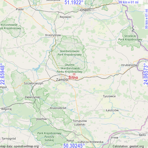
Sitno GPS coordinates[2]
50° 44' 57.984" North, 23° 21' 45.36" East
| Map corner | latitude | longitude |
|---|---|---|
| Upper-left | 51.1922°, | 22.65948° |
| Center: | 50.74944°, | 23.3626° |
| Lower-right: | 50.30245°, | 24.06573° |
| Map W x H: | 98.9×98.9 km | = 61.5×61.5mi |
| max Lat: | 54.83135° ⇑61.5% North |
| Sitno: | 50.74944° |
| min Lat: | ⇓38.5% South 49.21328° |
| min Long | Sitno | max Long |
| 14.20249° | 23.3626° | 24.03723° |
| W 98.2%⇐ | ⇒1.8% E |
Elevation
Elevation of Sitno is 213 m = 699 ft, and this is 21.6 m = 71 ft above average elevation for this country.
| Max E: |
974 m = 3196 ft | 35.5% |
| Sitno | 213 m 699 ft | |
| Avg. | 191.4 m = 628 ft | |
Min E: |
-3 m = -10 ft | 64.5% |
See also: Poland elevation on elevation.city.
Geographical zone
Sitno is located in North temperate zone (between Tropic of Cancer and the Arctic Circle). Distance of this North polar circle is 1758.4 km =1092.6 mi to North.| Distance of | km | miles | from Sitno |
|---|---|---|---|
| North Pole | 4364.3 | 2711.8 | to North |
| Arctic Circle | 1758.4 | 1092.6 | to North |
| Tropic Cancer | 3036.9 | 1887 | to South |
| Equator | 5642.8 | 3506.3 | to South |


Nearby cities:
15 places around Sitno: (largest is in red/bold)
• Dębowiec
5.9 km =3.7 mi,  338°
338°
• Grabowiec
15.4 km =9.6 mi,  58°
58°
• Izbica
21.3 km =13.2 mi,  316°
316°
• Komarów-Osada
15.7 km =9.8 mi,  148°
148°
• Krasne
18.4 km =11.4 mi,  313°
313°
• Kraśniczyn
20.3 km =12.6 mi,  357°
357°
• Krynice
18 km =11.2 mi,  175°
175°
• Miączyn
9.8 km =6.1 mi,  97°
97°
• Nielisz
23.1 km =14.4 mi,  284°
284°
• Skierbieszów
11.4 km =7.1 mi, 358°
• Stary Zamość
15.6 km =9.7 mi,  300°
300°
• Wojsławice
22.8 km =14.2 mi,  34°
34°
• Wysokie
9.9 km =6.2 mi,  272°
272°
• Zamość
8.3 km =5.2 mi,  249°
249°
• Łabunie
10.5 km =6.5 mi, 178°
Sources, notices
• [Note1] Compared only with cities in Poland existing in our database
• [Src1] Map data: © OpenStreetMap contributors (CC-BY-SA)
• [Src2] Other city data from geonames.org with taken over terms of usage.
• [Src3] Geographical zone / Annual Mean Temperature by Robert A. Rohde @ Wikipedia
