Jazgarzew geodata
Jazgarzew (Mazovia) is a populated place; located in Poland in Europe/Warsaw (GMT+2) time zone. With population of 693 people, there are 3082 cities with bigger population in this country. Compared to other cities in Poland, 66.3% of cities are located further ↓South; 72.6% of cities are located further ←West and 76.9% of cities have higher elevation than Jazgarzew. Note1


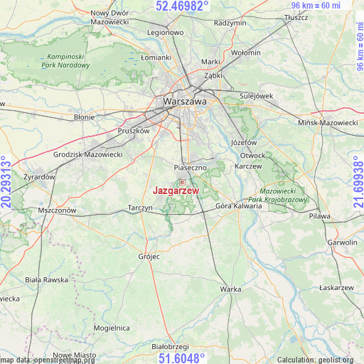
Jazgarzew GPS coordinates[2]
52° 2' 21.84" North, 20° 59' 46.5" East
| Map corner | latitude | longitude |
|---|---|---|
| Upper-left | 52.46982°, | 20.29313° |
| Center: | 52.0394°, | 20.99625° |
| Lower-right: | 51.6048°, | 21.69938° |
| Map W x H: | 96.2×96.2 km | = 59.8×59.8mi |
| max Lat: | 54.83135° ⇑33.7% North |
| Jazgarzew: | 52.0394° |
| min Lat: | ⇓66.3% South 49.21328° |
| min Long | Jazgarzew | max Long |
| 14.20249° | 20.99625° | 24.03723° |
| W 72.6%⇐ | ⇒27.4% E |
Elevation
Elevation of Jazgarzew is 106 m = 348 ft, and this is 85.4 m = 280 ft below average elevation for this country.
| Max E: |
974 m = 3196 ft | 76.9% |
| Avg. | 191.4 m = 628 ft | |
| Jazgarzew | 106 m = 348 ft | |
Min E: |
-3 m = -10 ft | 23.1% |
See also: Poland elevation on elevation.city.
Geographical zone
Jazgarzew is located in North temperate zone (between Tropic of Cancer and the Arctic Circle). Distance of this North polar circle is 1614.9 km =1003.5 mi to North.| Distance of | km | miles | from Jazgarzew |
|---|---|---|---|
| North Pole | 4220.8 | 2622.7 | to North |
| Arctic Circle | 1614.9 | 1003.5 | to North |
| Tropic Cancer | 3180.3 | 1976.1 | to South |
| Equator | 5786.2 | 3595.4 | to South |


Nearby cities:
15 places around Jazgarzew: (largest is in red/bold)
• Baniocha
10.1 km =6.3 mi,  104°
104°
• Chylice
6.3 km =3.9 mi,  46°
46°
• Chyliczki
7.2 km =4.5 mi,  44°
44°
• Czarnów
7.2 km =4.5 mi,  74°
74°
• Gołków
1.7 km =1.1 mi,  278°
278°
• Józefosław
7.6 km =4.7 mi,  26°
26°
• Kamionka
2.3 km =1.4 mi,  334°
334°
• Konstancin-Jeziorna
10.3 km =6.4 mi, 53°
• Lesznowola
7.1 km =4.4 mi,  323°
323°
• Mysiadło
7.1 km =4.4 mi,  12°
12°
• Nowa Iwiczna
5.8 km =3.6 mi, 5°
• Piaseczno
5 km =3.1 mi,  22°
22°
• Prażmów
11.4 km =7.1 mi,  194°
194°
• Zalesie Górne
3.1 km =1.9 mi,  115°
115°
• Żabieniec
4.1 km =2.5 mi,  59°
59°
Sources, notices
• [Note1] Compared only with cities in Poland existing in our database
• [Src1] Map data: © OpenStreetMap contributors (CC-BY-SA)
• [Src2] Other city data from geonames.org with taken over terms of usage.
• [Src3] Geographical zone / Annual Mean Temperature by Robert A. Rohde @ Wikipedia
