Gołków geodata
Gołków (Mazovia) is a populated place; located in Poland in Europe/Warsaw (GMT+2) time zone. With population of 959 people, there are 2579 cities with bigger population in this country. Compared to other cities in Poland, 66.4% of cities are located further ↓South; 72.1% of cities are located further ←West and 77.6% of cities have higher elevation than Gołków. Note1


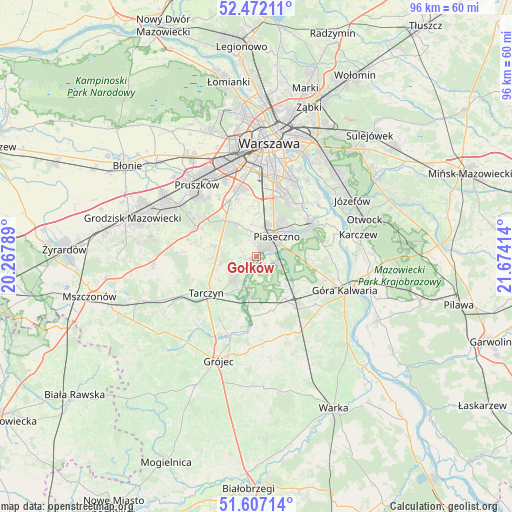
Gołków GPS coordinates[2]
52° 2' 30.192" North, 20° 58' 15.636" East
| Map corner | latitude | longitude |
|---|---|---|
| Upper-left | 52.47211°, | 20.26789° |
| Center: | 52.04172°, | 20.97101° |
| Lower-right: | 51.60714°, | 21.67414° |
| Map W x H: | 96.2×96.2 km | = 59.8×59.8mi |
| max Lat: | 54.83135° ⇑33.6% North |
| Gołków: | 52.04172° |
| min Lat: | ⇓66.4% South 49.21328° |
| min Long | Gołków | max Long |
| 14.20249° | 20.97101° | 24.03723° |
| W 72.1%⇐ | ⇒27.9% E |
Elevation
Elevation of Gołków is 104 m = 341 ft, and this is 87.4 m = 287 ft below average elevation for this country.
| Max E: |
974 m = 3196 ft | 77.6% |
| Avg. | 191.4 m = 628 ft | |
| Gołków | 104 m = 341 ft | |
Min E: |
-3 m = -10 ft | 22.4% |
See also: Poland elevation on elevation.city.
Geographical zone
Gołków is located in North temperate zone (between Tropic of Cancer and the Arctic Circle). Distance of this North polar circle is 1614.7 km =1003.3 mi to North.| Distance of | km | miles | from Gołków |
|---|---|---|---|
| North Pole | 4220.6 | 2622.6 | to North |
| Arctic Circle | 1614.7 | 1003.3 | to North |
| Tropic Cancer | 3180.6 | 1976.3 | to South |
| Equator | 5786.5 | 3595.6 | to South |


Nearby cities:
15 places around Gołków: (largest is in red/bold)
• Chylice
7.5 km =4.7 mi,  56°
56°
• Chyliczki
8.3 km =5.2 mi,  54°
54°
• Czarnów
8.8 km =5.5 mi,  79°
79°
• Jaworowa
11.5 km =7.1 mi,  355°
355°
• Jazgarzew
1.7 km =1.1 mi,  98°
98°
• Józefosław
8.3 km =5.2 mi,  38°
38°
• Kamionka
2 km =1.2 mi,  21°
21°
• Lesznowola
6 km =3.7 mi,  335°
335°
• Mysiadło
7.5 km =4.7 mi,  25°
25°
• Nowa Iwiczna
6 km =3.7 mi, 22°
• Piaseczno
5.7 km =3.5 mi, 39°
• Prażmów
11.3 km =7 mi,  185°
185°
• Tarczyn
11.5 km =7.1 mi,  234°
234°
• Zalesie Górne
4.7 km =2.9 mi,  109°
109°
• Żabieniec
5.6 km =3.5 mi,  70°
70°
Sources, notices
• [Note1] Compared only with cities in Poland existing in our database
• [Src1] Map data: © OpenStreetMap contributors (CC-BY-SA)
• [Src2] Other city data from geonames.org with taken over terms of usage.
• [Src3] Geographical zone / Annual Mean Temperature by Robert A. Rohde @ Wikipedia
