Czarnów geodata
Czarnów (Mazovia) is a populated place; located in Poland in Europe/Warsaw (GMT+2) time zone. With population of 600 people, there are 3270 cities with bigger population in this country. Compared to other cities in Poland, 66.5% of cities are located further ↓South; 74.5% of cities are located further ←West and 80.2% of cities have higher elevation than Czarnów. Note1
Administrative division(s):
- Level 1: Mazovia
- Level 2: Powiat piaseczyński
- Level 3: Konstancin-Jeziorna


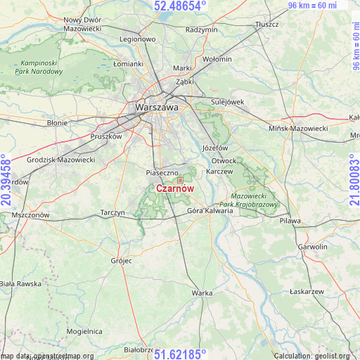
Czarnów GPS coordinates[2]
52° 3' 22.644" North, 21° 5' 51.72" East
| Map corner | latitude | longitude |
|---|---|---|
| Upper-left | 52.48654°, | 20.39458° |
| Center: | 52.05629°, | 21.0977° |
| Lower-right: | 51.62185°, | 21.80083° |
| Map W x H: | 96.1×96.1 km | = 59.7×59.7mi |
| max Lat: | 54.83135° ⇑33.5% North |
| Czarnów: | 52.05629° |
| min Lat: | ⇓66.5% South 49.21328° |
| min Long | Czarnów | max Long |
| 14.20249° | 21.0977° | 24.03723° |
| W 74.5%⇐ | ⇒25.5% E |
Elevation
Elevation of Czarnów is 99 m = 325 ft, and this is 92.4 m = 303 ft below average elevation for this country.
| Max E: |
974 m = 3196 ft | 80.2% |
| Avg. | 191.4 m = 628 ft | |
| Czarnów | 99 m = 325 ft | |
Min E: |
-3 m = -10 ft | 19.8% |
See also: Poland elevation on elevation.city.
Geographical zone
Czarnów is located in North temperate zone (between Tropic of Cancer and the Arctic Circle). Distance of this North polar circle is 1613.1 km =1002.3 mi to North.| Distance of | km | miles | from Czarnów |
|---|---|---|---|
| North Pole | 4218.9 | 2621.5 | to North |
| Arctic Circle | 1613.1 | 1002.3 | to North |
| Tropic Cancer | 3182.2 | 1977.3 | to South |
| Equator | 5788.1 | 3596.6 | to South |


Nearby cities:
15 places around Czarnów: (largest is in red/bold)
• Baniocha
5.3 km =3.3 mi,  146°
146°
• Bielawa
6.3 km =3.9 mi,  21°
21°
• Chylice
3.4 km =2.1 mi,  315°
315°
• Chyliczki
3.7 km =2.3 mi,  329°
329°
• Gołków
8.8 km =5.5 mi,  259°
259°
• Jazgarzew
7.2 km =4.5 mi,  254°
254°
• Józefosław
6 km =3.7 mi, 324°
• Kabaty
8.3 km =5.2 mi,  352°
352°
• Kamionka
7.9 km =4.9 mi,  271°
271°
• Konstancin-Jeziorna
4.4 km =2.7 mi, 18°
• Mysiadło
7.4 km =4.6 mi,  313°
313°
• Nowa Iwiczna
7.5 km =4.7 mi,  301°
301°
• Piaseczno
5.8 km =3.6 mi, 298°
• Zalesie Górne
5.3 km =3.3 mi,  232°
232°
• Żabieniec
3.4 km =2.1 mi, 274°
Sources, notices
• [Note1] Compared only with cities in Poland existing in our database
• [Src1] Map data: © OpenStreetMap contributors (CC-BY-SA)
• [Src2] Other city data from geonames.org with taken over terms of usage.
• [Src3] Geographical zone / Annual Mean Temperature by Robert A. Rohde @ Wikipedia
