Konstancin-Jeziorna geodata
Konstancin-Jeziorna (Mazovia) is a seat of a third-order administrative division; located in Poland in Europe/Warsaw (GMT+2) time zone. With population of 16,548 people, there are 302 cities with bigger population in this country. Compared to other cities in Poland, 67.7% of cities are located further ↓South; 74.6% of cities are located further ←West and 85.2% of cities have higher elevation than Konstancin-Jeziorna. Note1
Administrative division(s):
- Level 1: Mazovia
- Level 2: Powiat piaseczyński
- Level 3: Konstancin-Jeziorna


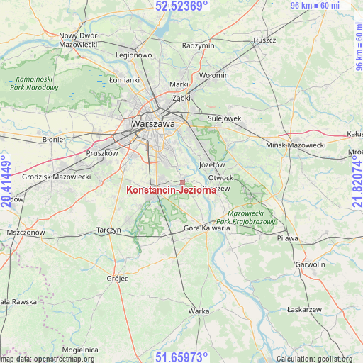
Konstancin-Jeziorna GPS coordinates[2]
52° 5' 37.68" North, 21° 7' 3.396" East
| Map corner | latitude | longitude |
|---|---|---|
| Upper-left | 52.52369°, | 20.41449° |
| Center: | 52.0938°, | 21.11761° |
| Lower-right: | 51.65973°, | 21.82074° |
| Map W x H: | 96.1×96.1 km | = 59.7×59.7mi |
| max Lat: | 54.83135° ⇑32.3% North |
| Konstancin-Jeziorna: | 52.0938° |
| min Lat: | ⇓67.7% South 49.21328° |
| min Long | Konstancin-Jezi | max Long |
| 14.20249° | 21.11761° | 24.03723° |
| W 74.6%⇐ | ⇒25.4% E |
Elevation
Elevation of Konstancin-Jeziorna is 89 m = 292 ft, and this is 102.4 m = 336 ft below average elevation for this country.
| Max E: |
974 m = 3196 ft | 85.2% |
| Avg. | 191.4 m = 628 ft | |
| Konstancin-Jeziorna | 89 m = 292 ft | |
Min E: |
-3 m = -10 ft | 14.8% |
See also: Poland elevation on elevation.city.
Geographical zone
Konstancin-Jeziorna is located in North temperate zone (between Tropic of Cancer and the Arctic Circle). Distance of this North polar circle is 1608.9 km =999.7 mi to North.| Distance of | km | miles | from Konstancin-Jeziorna |
|---|---|---|---|
| North Pole | 4214.8 | 2619 | to North |
| Arctic Circle | 1608.9 | 999.7 | to North |
| Tropic Cancer | 3186.4 | 1979.9 | to South |
| Equator | 5792.3 | 3599.2 | to South |


Nearby cities:
15 places around Konstancin-Jeziorna: (largest is in red/bold)
• Baniocha
8.7 km =5.4 mi,  169°
169°
• Bielawa
1.9 km =1.2 mi,  29°
29°
• Chylice
4.1 km =2.5 mi,  245°
245°
• Chyliczki
3.4 km =2.1 mi, 253°
• Czarnów
4.4 km =2.7 mi,  198°
198°
• Józefosław
4.9 km =3 mi,  278°
278°
• Kabaty
4.7 km =2.9 mi,  328°
328°
• Karczew
9.2 km =5.7 mi,  102°
102°
• Mysiadło
6.8 km =4.2 mi, 277°
• Nowa Iwiczna
7.8 km =4.8 mi,  268°
268°
• Piaseczno
6.5 km =4 mi,  257°
257°
• Ursynów
7.8 km =4.8 mi,  323°
323°
• Wilanów
8 km =5 mi,  345°
345°
• Zalesie Górne
9.2 km =5.7 mi,  216°
216°
• Żabieniec
6.2 km =3.9 mi,  230°
230°
Sources, notices
• [Note1] Compared only with cities in Poland existing in our database
• [Src1] Map data: © OpenStreetMap contributors (CC-BY-SA)
• [Src2] Other city data from geonames.org with taken over terms of usage.
• [Src3] Geographical zone / Annual Mean Temperature by Robert A. Rohde @ Wikipedia
