Zalesie Górne geodata
Zalesie Górne (Mazovia) is a populated place; located in Poland in Europe/Warsaw (GMT+2) time zone. With population of 3,099 people, there are 1024 cities with bigger population in this country. Compared to other cities in Poland, 66.1% of cities are located further ↓South; 73.3% of cities are located further ←West and 73.1% of cities have higher elevation than Zalesie Górne. Note1


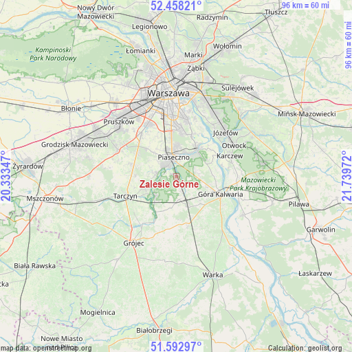
Zalesie Górne GPS coordinates[2]
52° 1' 39.648" North, 21° 2' 11.724" East
| Map corner | latitude | longitude |
|---|---|---|
| Upper-left | 52.45821°, | 20.33347° |
| Center: | 52.02768°, | 21.03659° |
| Lower-right: | 51.59297°, | 21.73972° |
| Map W x H: | 96.2×96.2 km | = 59.8×59.8mi |
| max Lat: | 54.83135° ⇑33.9% North |
| Zalesie Górne: | 52.02768° |
| min Lat: | ⇓66.1% South 49.21328° |
| min Long | Zalesie Górne | max Long |
| 14.20249° | 21.03659° | 24.03723° |
| W 73.3%⇐ | ⇒26.7% E |
Elevation
Elevation of Zalesie Górne is 115 m = 377 ft, and this is 76.4 m = 251 ft below average elevation for this country.
| Max E: |
974 m = 3196 ft | 73.1% |
| Avg. | 191.4 m = 628 ft | |
| Zalesie Górne | 115 m = 377 ft | |
Min E: |
-3 m = -10 ft | 26.9% |
See also: Poland elevation on elevation.city.
Geographical zone
Zalesie Górne is located in North temperate zone (between Tropic of Cancer and the Arctic Circle). Distance of this North polar circle is 1616.2 km =1004.3 mi to North.| Distance of | km | miles | from Zalesie Górne |
|---|---|---|---|
| North Pole | 4222.1 | 2623.5 | to North |
| Arctic Circle | 1616.2 | 1004.3 | to North |
| Tropic Cancer | 3179 | 1975.3 | to South |
| Equator | 5784.9 | 3594.6 | to South |


Nearby cities:
15 places around Zalesie Górne: (largest is in red/bold)
• Baniocha
7.2 km =4.5 mi,  99°
99°
• Bielawa
11.1 km =6.9 mi,  35°
35°
• Chylice
5.9 km =3.7 mi,  17°
17°
• Chyliczki
6.8 km =4.2 mi, 19°
• Czarnów
5.3 km =3.3 mi,  52°
52°
• Gołków
4.7 km =2.9 mi,  289°
289°
• Jazgarzew
3.1 km =1.9 mi,  295°
295°
• Józefosław
8.1 km =5 mi,  4°
4°
• Kamionka
5.1 km =3.2 mi,  312°
312°
• Konstancin-Jeziorna
9.2 km =5.7 mi, 36°
• Lesznowola
9.9 km =6.2 mi,  315°
315°
• Mysiadło
8.4 km =5.2 mi,  351°
351°
• Nowa Iwiczna
7.4 km =4.6 mi,  342°
342°
• Piaseczno
6 km =3.7 mi, 351°
• Żabieniec
3.5 km =2.2 mi,  12°
12°
Sources, notices
• [Note1] Compared only with cities in Poland existing in our database
• [Src1] Map data: © OpenStreetMap contributors (CC-BY-SA)
• [Src2] Other city data from geonames.org with taken over terms of usage.
• [Src3] Geographical zone / Annual Mean Temperature by Robert A. Rohde @ Wikipedia
