Iwkowa geodata
Iwkowa (Lesser Poland) is a seat of a third-order administrative division; located in Poland in Europe/Warsaw (GMT+2) time zone. With population of 2,699 people, there are 1169 cities with bigger population in this country. Compared to other cities in Poland, 91.1% of cities are located further ↑North; 66.2% of cities are located further ←West and 84.4% of cities have lower elevation than Iwkowa. Note1


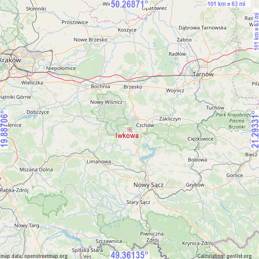
Iwkowa GPS coordinates[2]
49° 49' 1.776" North, 20° 35' 24.648" East
| Map corner | latitude | longitude |
|---|---|---|
| Upper-left | 50.26871°, | 19.88706° |
| Center: | 49.81716°, | 20.59018° |
| Lower-right: | 49.36135°, | 21.29331° |
| Map W x H: | 100.9×100.9 km | = 62.7×62.7mi |
| max Lat: | 54.83135° ⇑91.1% North |
| Iwkowa: | 49.81716° |
| min Lat: | ⇓8.9% South 49.21328° |
| min Long | Iwkowa | max Long |
| 14.20249° | 20.59018° | 24.03723° |
| W 66.2%⇐ | ⇒33.8% E |
Elevation
Elevation of Iwkowa is 287 m = 942 ft, and this is 95.6 m = 314 ft above average elevation for this country.
| Max E: |
974 m = 3196 ft | 15.6% |
| Iwkowa | 287 m 942 ft | |
| Avg. | 191.4 m = 628 ft | |
Min E: |
-3 m = -10 ft | 84.4% |
See also: Poland elevation on elevation.city.
Geographical zone
Iwkowa is located in North temperate zone (between Tropic of Cancer and the Arctic Circle). Distance of this North polar circle is 1862 km =1157 mi to North.| Distance of | km | miles | from Iwkowa |
|---|---|---|---|
| North Pole | 4467.9 | 2776.2 | to North |
| Arctic Circle | 1862 | 1157 | to North |
| Tropic Cancer | 2933.2 | 1822.6 | to South |
| Equator | 5539.1 | 3441.8 | to South |


Nearby cities:
15 places around Iwkowa: (largest is in red/bold)
• Czchów
6.9 km =4.3 mi,  70°
70°
• Gnojnik
8.6 km =5.3 mi,  8°
8°
• Gródek Nad Dunajcem
12.9 km =8 mi,  127°
127°
• Gwoździec
14.7 km =9.1 mi,  55°
55°
• Laskowa
11.8 km =7.3 mi,  238°
238°
• Lipnica Murowana
6.6 km =4.1 mi,  315°
315°
• Niedźwiedza
12.7 km =7.9 mi,  45°
45°
• Nowy Wiśnicz
14.3 km =8.9 mi, 319°
• Okocim
14.7 km =9.1 mi,  3°
3°
• Poręba Spytkowska
13.9 km =8.6 mi,  349°
349°
• Stary Wiśnicz
14.2 km =8.8 mi,  328°
328°
• Złota
10.2 km =6.3 mi, 46°
• Łoniowa
13.3 km =8.3 mi,  34°
34°
• Łososina Dolna
8.1 km =5 mi,  158°
158°
• Żegocina
12.2 km =7.6 mi,  268°
268°
Sources, notices
• [Note1] Compared only with cities in Poland existing in our database
• [Src1] Map data: © OpenStreetMap contributors (CC-BY-SA)
• [Src2] Other city data from geonames.org with taken over terms of usage.
• [Src3] Geographical zone / Annual Mean Temperature by Robert A. Rohde @ Wikipedia
