Gnojnik geodata
Gnojnik (Lesser Poland) is a seat of a third-order administrative division; located in Poland in Europe/Warsaw (GMT+2) time zone. With population of 2,344 people, there are 1304 cities with bigger population in this country. Compared to other cities in Poland, 87.8% of cities are located further ↑North; 66.4% of cities are located further ←West and 74.2% of cities have lower elevation than Gnojnik. Note1


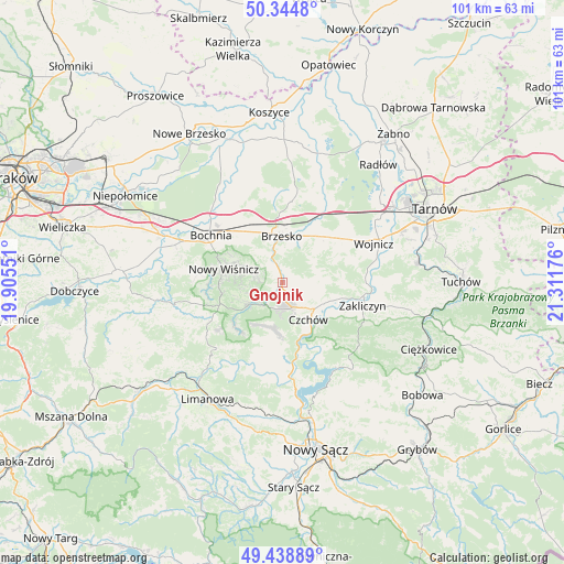
Gnojnik GPS coordinates[2]
49° 53' 38.292" North, 20° 36' 31.068" East
| Map corner | latitude | longitude |
|---|---|---|
| Upper-left | 50.3448°, | 19.90551° |
| Center: | 49.89397°, | 20.60863° |
| Lower-right: | 49.43889°, | 21.31176° |
| Map W x H: | 100.7×100.7 km | = 62.6×62.6mi |
| max Lat: | 54.83135° ⇑87.8% North |
| Gnojnik: | 49.89397° |
| min Lat: | ⇓12.2% South 49.21328° |
| min Long | Gnojnik | max Long |
| 14.20249° | 20.60863° | 24.03723° |
| W 66.4%⇐ | ⇒33.6% E |
Elevation
Elevation of Gnojnik is 243 m = 797 ft, and this is 51.6 m = 169 ft above average elevation for this country.
| Max E: |
974 m = 3196 ft | 25.8% |
| Gnojnik | 243 m 797 ft | |
| Avg. | 191.4 m = 628 ft | |
Min E: |
-3 m = -10 ft | 74.2% |
See also: Poland elevation on elevation.city.
Geographical zone
Gnojnik is located in North temperate zone (between Tropic of Cancer and the Arctic Circle). Distance of this North polar circle is 1853.5 km =1151.7 mi to North.| Distance of | km | miles | from Gnojnik |
|---|---|---|---|
| North Pole | 4459.4 | 2770.9 | to North |
| Arctic Circle | 1853.5 | 1151.7 | to North |
| Tropic Cancer | 2941.8 | 1827.9 | to South |
| Equator | 5547.7 | 3447.2 | to South |


Nearby cities:
15 places around Gnojnik: (largest is in red/bold)
• Brzesko
8.4 km =5.2 mi,  358°
358°
• Czchów
8.1 km =5 mi,  140°
140°
• Gwoździec
10.8 km =6.7 mi,  91°
91°
• Iwkowa
8.6 km =5.3 mi,  188°
188°
• Jadowniki
7.7 km =4.8 mi,  19°
19°
• Jasień
8.8 km =5.5 mi,  342°
342°
• Jaworsko
10.2 km =6.3 mi,  82°
82°
• Lipnica Murowana
7.1 km =4.4 mi,  236°
236°
• Niedźwiedza
7.8 km =4.8 mi, 87°
• Okocim
6.1 km =3.8 mi, 355°
• Porąbka Uszewska
8 km =5 mi,  47°
47°
• Poręba Spytkowska
6.4 km =4 mi,  322°
322°
• Stary Wiśnicz
9.4 km =5.8 mi,  291°
291°
• Złota
6.2 km =3.9 mi,  103°
103°
• Łoniowa
6.6 km =4.1 mi,  67°
67°
Sources, notices
• [Note1] Compared only with cities in Poland existing in our database
• [Src1] Map data: © OpenStreetMap contributors (CC-BY-SA)
• [Src2] Other city data from geonames.org with taken over terms of usage.
• [Src3] Geographical zone / Annual Mean Temperature by Robert A. Rohde @ Wikipedia
