Łoniowa geodata
Łoniowa (Lesser Poland) is a populated place; located in Poland in Europe/Warsaw (GMT+2) time zone. With population of 951 people, there are 2590 cities with bigger population in this country. Compared to other cities in Poland, 86.8% of cities are located further ↑North; 67.5% of cities are located further ←West and 77.9% of cities have lower elevation than Łoniowa. Note1


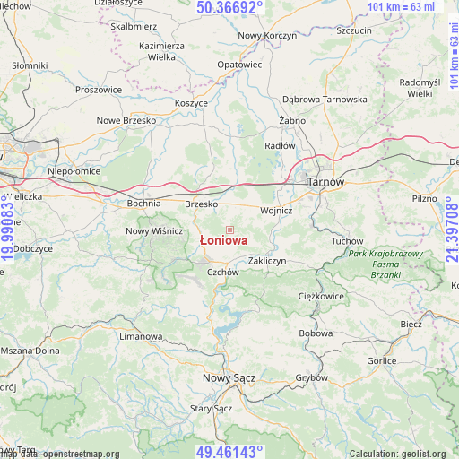
Łoniowa GPS coordinates[2]
49° 54' 58.68" North, 20° 41' 38.22" East
| Map corner | latitude | longitude |
|---|---|---|
| Upper-left | 50.36692°, | 19.99083° |
| Center: | 49.9163°, | 20.69395° |
| Lower-right: | 49.46143°, | 21.39708° |
| Map W x H: | 100.7×100.7 km | = 62.6×62.6mi |
| max Lat: | 54.83135° ⇑86.8% North |
| Łoniowa: | 49.9163° |
| min Lat: | ⇓13.2% South 49.21328° |
| min Long | Łoniowa | max Long |
| 14.20249° | 20.69395° | 24.03723° |
| W 67.5%⇐ | ⇒32.5% E |
Elevation
Elevation of Łoniowa is 257 m = 843 ft, and this is 65.6 m = 215 ft above average elevation for this country.
| Max E: |
974 m = 3196 ft | 22.1% |
| Łoniowa | 257 m 843 ft | |
| Avg. | 191.4 m = 628 ft | |
Min E: |
-3 m = -10 ft | 77.9% |
See also: Poland elevation on elevation.city.
Geographical zone
Łoniowa is located in North temperate zone (between Tropic of Cancer and the Arctic Circle). Distance of this North polar circle is 1851 km =1150.2 mi to North.| Distance of | km | miles | from Łoniowa |
|---|---|---|---|
| North Pole | 4456.9 | 2769.4 | to North |
| Arctic Circle | 1851 | 1150.2 | to North |
| Tropic Cancer | 2944.3 | 1829.5 | to South |
| Equator | 5550.2 | 3448.7 | to South |


Nearby cities:
15 places around Łoniowa: (largest is in red/bold)
• Brzesko
8.6 km =5.3 mi,  313°
313°
• Czchów
8.8 km =5.5 mi,  186°
186°
• Dębno
5.9 km =3.7 mi,  18°
18°
• Gnojnik
6.6 km =4.1 mi,  247°
247°
• Gwoździec
5.4 km =3.4 mi,  119°
119°
• Jadowniki
5.9 km =3.7 mi,  323°
323°
• Jaworsko
4.2 km =2.6 mi,  105°
105°
• Maszkienice
8.1 km =5 mi,  356°
356°
• Niedźwiedza
2.7 km =1.7 mi,  141°
141°
• Okocim
7.5 km =4.7 mi,  298°
298°
• Olszyny
9.3 km =5.8 mi, 106°
• Porąbka Uszewska
2.9 km =1.8 mi, 355°
• Sterkowiec
8.8 km =5.5 mi,  353°
353°
• Wola Dębińska
7.3 km =4.5 mi, 356°
• Złota
4 km =2.5 mi,  180°
180°
Sources, notices
• [Note1] Compared only with cities in Poland existing in our database
• [Src1] Map data: © OpenStreetMap contributors (CC-BY-SA)
• [Src2] Other city data from geonames.org with taken over terms of usage.
• [Src3] Geographical zone / Annual Mean Temperature by Robert A. Rohde @ Wikipedia
