Złota geodata
Złota (Lesser Poland) is a populated place; located in Poland in Europe/Warsaw (GMT+2) time zone. With population of 1,368 people, there are 2009 cities with bigger population in this country. Compared to other cities in Poland, 88.4% of cities are located further ↑North; 67.5% of cities are located further ←West and 86.2% of cities have lower elevation than Złota. Note1


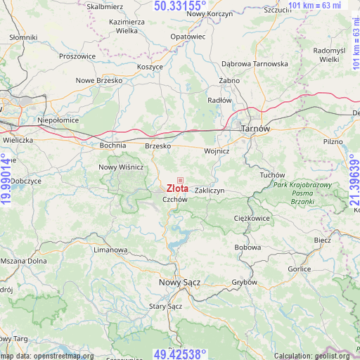
Złota GPS coordinates[2]
49° 52' 50.124" North, 20° 41' 35.736" East
| Map corner | latitude | longitude |
|---|---|---|
| Upper-left | 50.33155°, | 19.99014° |
| Center: | 49.88059°, | 20.69326° |
| Lower-right: | 49.42538°, | 21.39639° |
| Map W x H: | 100.8×100.8 km | = 62.6×62.6mi |
| max Lat: | 54.83135° ⇑88.4% North |
| Złota: | 49.88059° |
| min Lat: | ⇓11.6% South 49.21328° |
| min Long | Złota | max Long |
| 14.20249° | 20.69326° | 24.03723° |
| W 67.5%⇐ | ⇒32.5% E |
Elevation
Elevation of Złota is 297 m = 974 ft, and this is 105.6 m = 346 ft above average elevation for this country.
| Max E: |
974 m = 3196 ft | 13.8% |
| Złota | 297 m 974 ft | |
| Avg. | 191.4 m = 628 ft | |
Min E: |
-3 m = -10 ft | 86.2% |
See also: Poland elevation on elevation.city.
Geographical zone
Złota is located in North temperate zone (between Tropic of Cancer and the Arctic Circle). Distance of this North polar circle is 1855 km =1152.6 mi to North.| Distance of | km | miles | from Złota |
|---|---|---|---|
| North Pole | 4460.9 | 2771.9 | to North |
| Arctic Circle | 1855 | 1152.6 | to North |
| Tropic Cancer | 2940.3 | 1827 | to South |
| Equator | 5546.2 | 3446.2 | to South |


Nearby cities:
15 places around Złota: (largest is in red/bold)
• Czchów
4.9 km =3 mi,  190°
190°
• Dębno
9.8 km =6.1 mi,  11°
11°
• Gnojnik
6.2 km =3.9 mi,  283°
283°
• Gwoździec
4.9 km =3 mi,  74°
74°
• Iwkowa
10.2 km =6.3 mi,  226°
226°
• Jadowniki
9.4 km =5.8 mi,  338°
338°
• Jaworsko
5 km =3.1 mi,  55°
55°
• Niedźwiedza
2.5 km =1.6 mi,  42°
42°
• Okocim
10 km =6.2 mi,  319°
319°
• Olszyny
9.1 km =5.7 mi,  81°
81°
• Porąbka Uszewska
6.9 km =4.3 mi,  358°
358°
• Wielka Wieś
11.2 km =7 mi, 56°
• Wola Dębińska
11.3 km =7 mi, 358°
• Zakliczyn
8.8 km =5.5 mi,  108°
108°
• Łoniowa
4 km =2.5 mi,  0°
0°
Sources, notices
• [Note1] Compared only with cities in Poland existing in our database
• [Src1] Map data: © OpenStreetMap contributors (CC-BY-SA)
• [Src2] Other city data from geonames.org with taken over terms of usage.
• [Src3] Geographical zone / Annual Mean Temperature by Robert A. Rohde @ Wikipedia
