Drohobyczka geodata
Drohobyczka (Subcarpathian) is a populated place; located in Poland in Europe/Warsaw (GMT+2) time zone. With population of 1,000 people, there are 2459 cities with bigger population in this country. Compared to other cities in Poland, 89.5% of cities are located further ↑North; 89.7% of cities are located further ←West and 80.3% of cities have lower elevation than Drohobyczka. Note1


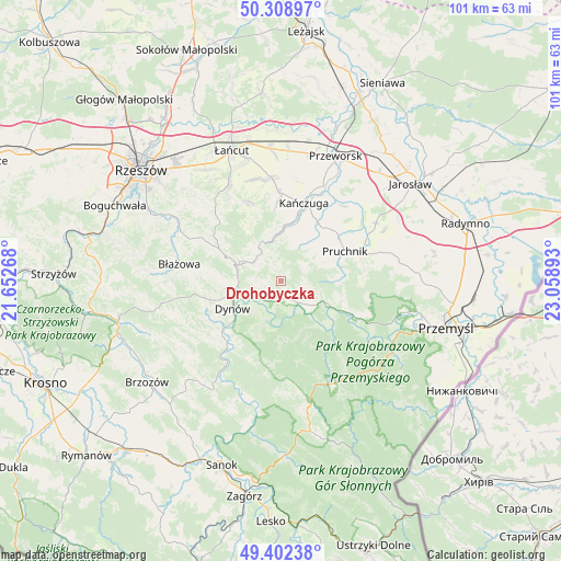
Drohobyczka GPS coordinates[2]
49° 51' 28.08" North, 22° 21' 20.88" East
| Map corner | latitude | longitude |
|---|---|---|
| Upper-left | 50.30897°, | 21.65268° |
| Center: | 49.8578°, | 22.3558° |
| Lower-right: | 49.40238°, | 23.05893° |
| Map W x H: | 100.8×100.8 km | = 62.6×62.6mi |
| max Lat: | 54.83135° ⇑89.5% North |
| Drohobyczka: | 49.8578° |
| min Lat: | ⇓10.5% South 49.21328° |
| min Long | Drohobyczka | max Long |
| 14.20249° | 22.3558° | 24.03723° |
| W 89.7%⇐ | ⇒10.3% E |
Elevation
Elevation of Drohobyczka is 267 m = 876 ft, and this is 75.6 m = 248 ft above average elevation for this country.
| Max E: |
974 m = 3196 ft | 19.7% |
| Drohobyczka | 267 m 876 ft | |
| Avg. | 191.4 m = 628 ft | |
Min E: |
-3 m = -10 ft | 80.3% |
See also: Poland elevation on elevation.city.
Geographical zone
Drohobyczka is located in North temperate zone (between Tropic of Cancer and the Arctic Circle). Distance of this North polar circle is 1857.5 km =1154.2 mi to North.| Distance of | km | miles | from Drohobyczka |
|---|---|---|---|
| North Pole | 4463.4 | 2773.4 | to North |
| Arctic Circle | 1857.5 | 1154.2 | to North |
| Tropic Cancer | 2937.7 | 1825.4 | to South |
| Equator | 5543.7 | 3444.7 | to South |


Nearby cities:
15 places around Drohobyczka: (largest is in red/bold)
• Babice
9.7 km =6 mi,  116°
116°
• Dubiecko
4.3 km =2.7 mi,  144°
144°
• Dynów
10 km =6.2 mi,  241°
241°
• Hadle Szklarskie
7.2 km =4.5 mi,  325°
325°
• Hucisko Nienadowskie
4.9 km =3 mi,  64°
64°
• Jawornik Polski
6.1 km =3.8 mi,  307°
307°
• Jodłówka
8.9 km =5.5 mi, 62°
• Kramarzówka
10.4 km =6.5 mi,  88°
88°
• Manasterz
8.6 km =5.3 mi,  355°
355°
• Nienadowa
6 km =3.7 mi, 122°
• Przedmieście Dubieckie
2.6 km =1.6 mi,  153°
153°
• Siedleczka
11.6 km =7.2 mi,  8°
8°
• Łopuszka Wielka
8.9 km =5.5 mi,  17°
17°
• Śliwnica
4.1 km =2.5 mi, 92°
• Świebodna
8 km =5 mi,  51°
51°
Sources, notices
• [Note1] Compared only with cities in Poland existing in our database
• [Src1] Map data: © OpenStreetMap contributors (CC-BY-SA)
• [Src2] Other city data from geonames.org with taken over terms of usage.
• [Src3] Geographical zone / Annual Mean Temperature by Robert A. Rohde @ Wikipedia
