Nienadowa geodata
Nienadowa (Subcarpathian) is a populated place; located in Poland in Europe/Warsaw (GMT+2) time zone. With population of 2,500 people, there are 1240 cities with bigger population in this country. Compared to other cities in Poland, 90.6% of cities are located further ↑North; 90.6% of cities are located further ←West and 75.8% of cities have lower elevation than Nienadowa. Note1


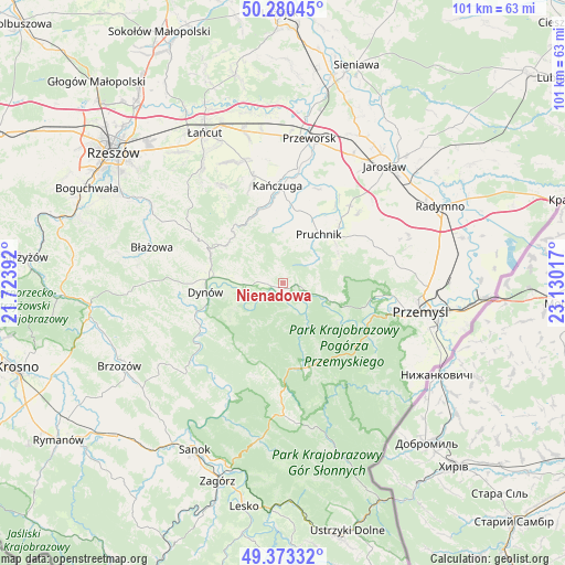
Nienadowa GPS coordinates[2]
49° 49' 44.436" North, 22° 25' 37.344" East
| Map corner | latitude | longitude |
|---|---|---|
| Upper-left | 50.28045°, | 21.72392° |
| Center: | 49.82901°, | 22.42704° |
| Lower-right: | 49.37332°, | 23.13017° |
| Map W x H: | 100.9×100.9 km | = 62.7×62.7mi |
| max Lat: | 54.83135° ⇑90.6% North |
| Nienadowa: | 49.82901° |
| min Lat: | ⇓9.4% South 49.21328° |
| min Long | Nienadowa | max Long |
| 14.20249° | 22.42704° | 24.03723° |
| W 90.6%⇐ | ⇒9.4% E |
Elevation
Elevation of Nienadowa is 249 m = 817 ft, and this is 57.6 m = 189 ft above average elevation for this country.
| Max E: |
974 m = 3196 ft | 24.2% |
| Nienadowa | 249 m 817 ft | |
| Avg. | 191.4 m = 628 ft | |
Min E: |
-3 m = -10 ft | 75.8% |
See also: Poland elevation on elevation.city.
Geographical zone
Nienadowa is located in North temperate zone (between Tropic of Cancer and the Arctic Circle). Distance of this North polar circle is 1860.7 km =1156.2 mi to North.| Distance of | km | miles | from Nienadowa |
|---|---|---|---|
| North Pole | 4466.6 | 2775.4 | to North |
| Arctic Circle | 1860.7 | 1156.2 | to North |
| Tropic Cancer | 2934.5 | 1823.4 | to South |
| Equator | 5540.5 | 3442.7 | to South |


Nearby cities:
15 places around Nienadowa: (largest is in red/bold)
• Babice
3.7 km =2.3 mi,  108°
108°
• Drohobyczka
6 km =3.7 mi,  302°
302°
• Dubiecko
2.6 km =1.6 mi,  262°
262°
• Hucisko Nienadowskie
5.4 km =3.4 mi,  352°
352°
• Jawornik Polski
12.1 km =7.5 mi, 304°
• Jodłówka
7.8 km =4.8 mi,  21°
21°
• Kramarzówka
6.4 km =4 mi,  56°
56°
• Krzywcza
9.1 km =5.7 mi, 111°
• Pruchnik
10.7 km =6.6 mi,  36°
36°
• Przedmieście Dubieckie
4.1 km =2.5 mi,  282°
282°
• Ruszelczyce
7 km =4.3 mi, 106°
• Węgierka
11.6 km =7.2 mi, 55°
• Łopuszka Wielka
12 km =7.5 mi, 348°
• Śliwnica
3.2 km =2 mi,  341°
341°
• Świebodna
8.3 km =5.2 mi,  7°
7°
Sources, notices
• [Note1] Compared only with cities in Poland existing in our database
• [Src1] Map data: © OpenStreetMap contributors (CC-BY-SA)
• [Src2] Other city data from geonames.org with taken over terms of usage.
• [Src3] Geographical zone / Annual Mean Temperature by Robert A. Rohde @ Wikipedia
