Manasterz geodata
Manasterz (Subcarpathian) is a populated place; located in Poland in Europe/Warsaw (GMT+2) time zone. With population of 1,149 people, there are 2260 cities with bigger population in this country. Compared to other cities in Poland, 86.3% of cities are located further ↑North; 89.6% of cities are located further ←West and 67.4% of cities have lower elevation than Manasterz. Note1
Administrative division(s):
- Level 1: Subcarpathian
- Level 2: Powiat przeworski
- Level 3: Jawornik Polski


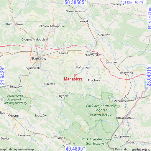
Manasterz GPS coordinates[2]
49° 56' 6.72" North, 22° 20' 45.672" East
| Map corner | latitude | longitude |
|---|---|---|
| Upper-left | 50.38565°, | 21.6429° |
| Center: | 49.9352°, | 22.34602° |
| Lower-right: | 49.4805°, | 23.04915° |
| Map W x H: | 100.6×100.6 km | = 62.5×62.5mi |
| max Lat: | 54.83135° ⇑86.3% North |
| Manasterz: | 49.9352° |
| min Lat: | ⇓13.7% South 49.21328° |
| min Long | Manasterz | max Long |
| 14.20249° | 22.34602° | 24.03723° |
| W 89.6%⇐ | ⇒10.4% E |
Elevation
Elevation of Manasterz is 221 m = 725 ft, and this is 29.6 m = 97 ft above average elevation for this country.
| Max E: |
974 m = 3196 ft | 32.6% |
| Manasterz | 221 m 725 ft | |
| Avg. | 191.4 m = 628 ft | |
Min E: |
-3 m = -10 ft | 67.4% |
See also: Poland elevation on elevation.city.
Geographical zone
Manasterz is located in North temperate zone (between Tropic of Cancer and the Arctic Circle). Distance of this North polar circle is 1848.9 km =1148.9 mi to North.| Distance of | km | miles | from Manasterz |
|---|---|---|---|
| North Pole | 4454.8 | 2768.1 | to North |
| Arctic Circle | 1848.9 | 1148.9 | to North |
| Tropic Cancer | 2946.4 | 1830.8 | to South |
| Equator | 5552.3 | 3450 | to South |


Nearby cities:
15 places around Manasterz: (largest is in red/bold)
• Drohobyczka
8.6 km =5.3 mi,  175°
175°
• Gać
10.2 km =6.3 mi,  5°
5°
• Hadle Szklarskie
4.3 km =2.7 mi,  231°
231°
• Hucisko Nienadowskie
8.2 km =5.1 mi,  141°
141°
• Husów
6.5 km =4 mi,  319°
319°
• Jawornik Polski
6.4 km =4 mi,  219°
219°
• Jodłówka
9.8 km =6.1 mi,  117°
117°
• Kańczuga
7.1 km =4.4 mi,  41°
41°
• Markowa
10.2 km =6.3 mi,  354°
354°
• Pantalowice
6.7 km =4.2 mi,  73°
73°
• Siedleczka
3.7 km =2.3 mi, 40°
• Sietesz
5.7 km =3.5 mi,  0°
0°
• Łopuszka Wielka
3.4 km =2.1 mi,  91°
91°
• Śliwnica
10 km =6.2 mi,  151°
151°
• Świebodna
7.8 km =4.8 mi, 117°
Sources, notices
• [Note1] Compared only with cities in Poland existing in our database
• [Src1] Map data: © OpenStreetMap contributors (CC-BY-SA)
• [Src2] Other city data from geonames.org with taken over terms of usage.
• [Src3] Geographical zone / Annual Mean Temperature by Robert A. Rohde @ Wikipedia
