Siedleczka geodata
Siedleczka (Subcarpathian) is a populated place; located in Poland in Europe/Warsaw (GMT+1) time zone. With population of 1,152 people, there are 2255 cities with bigger population in this country. Compared to other cities in Poland, 84.8% of cities are located further ↑North; 89.9% of cities are located further ←West and 65.3% of cities have lower elevation than Siedleczka. Note1


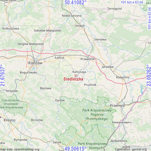
Siedleczka GPS coordinates[2]
49° 57' 38.196" North, 22° 22' 46.164" East
| Map corner | latitude | longitude |
|---|---|---|
| Upper-left | 50.41082°, | 21.67637° |
| Center: | 49.96061°, | 22.37949° |
| Lower-right: | 49.50615°, | 23.08262° |
| Map W x H: | 100.6×100.6 km | = 62.5×62.5mi |
| max Lat: | 54.83135° ⇑84.8% North |
| Siedleczka: | 49.96061° |
| min Lat: | ⇓15.2% South 49.21328° |
| min Long | Siedleczka | max Long |
| 14.20249° | 22.37949° | 24.03723° |
| W 89.9%⇐ | ⇒10.1% E |
Elevation
Elevation of Siedleczka is 215 m = 705 ft, and this is 23.6 m = 77 ft above average elevation for this country.
| Max E: |
974 m = 3196 ft | 34.7% |
| Siedleczka | 215 m 705 ft | |
| Avg. | 191.4 m = 628 ft | |
Min E: |
-3 m = -10 ft | 65.3% |
See also: Poland elevation on elevation.city.
Geographical zone
Siedleczka is located in North temperate zone (between Tropic of Cancer and the Arctic Circle). Distance of this North polar circle is 1846.1 km =1147.1 mi to North.| Distance of | km | miles | from Siedleczka |
|---|---|---|---|
| North Pole | 4452 | 2766.3 | to North |
| Arctic Circle | 1846.1 | 1147.1 | to North |
| Tropic Cancer | 2949.2 | 1832.5 | to South |
| Equator | 5555.1 | 3451.8 | to South |


Nearby cities:
15 places around Siedleczka: (largest is in red/bold)
• Gać
7.5 km =4.7 mi,  348°
348°
• Hadle Szklarskie
7.9 km =4.9 mi,  226°
226°
• Hucisko Nienadowskie
9.7 km =6 mi,  163°
163°
• Husów
7 km =4.3 mi,  287°
287°
• Jodłówka
9.7 km =6 mi,  139°
139°
• Kańczuga
3.4 km =2.1 mi,  42°
42°
• Krzeczowice
6.8 km =4.2 mi,  62°
62°
• Manasterz
3.7 km =2.3 mi,  220°
220°
• Markowa
8.1 km =5 mi,  334°
334°
• Pantalowice
4.1 km =2.5 mi,  103°
103°
• Rożniatów
9.9 km =6.2 mi,  78°
78°
• Sietesz
3.7 km =2.3 mi,  320°
320°
• Urzejowice
8.2 km =5.1 mi,  45°
45°
• Łopuszka Wielka
3.1 km =1.9 mi, 161°
• Świebodna
7.9 km =4.9 mi, 144°
Sources, notices
• [Note1] Compared only with cities in Poland existing in our database
• [Src1] Map data: © OpenStreetMap contributors (CC-BY-SA)
• [Src2] Other city data from geonames.org with taken over terms of usage.
• [Src3] Geographical zone / Annual Mean Temperature by Robert A. Rohde @ Wikipedia
