Canovanas geodata
Canovanas (Canóvanas) is a seat of a first-order administrative division; located in Puerto Rico in America/Puerto_Rico (GMT-4) time zone. With population of 8,437 people, there are 41 cities with bigger population in this country. Compared to other cities in Puerto Rico, 70.7% of cities are located further ↓South; 81.3% of cities are located further ←West and 79.1% of cities have higher elevation than Canovanas. Note1


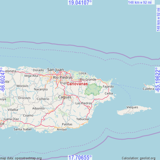
Canovanas GPS coordinates[2]
18° 22' 30.36" North, 65° 53' 57.624" West
| Map corner | latitude | longitude |
|---|---|---|
| Upper-left | 19.04107°, | -66.60247° |
| Center: | 18.3751°, | -65.89934° |
| Lower-right: | 17.70655°, | -65.19622° |
| Map W x H: | 148.4×148.4 km | = 92.2×92.2mi |
| max Lat: | 18.50078° ⇑29.3% North |
| Canovanas: | 18.3751° |
| min Lat: | ⇓70.7% South 17.95358° |
| min Long | Canovanas | max Long |
| -67.2499° | -65.89934° | -65.30099° |
| W 81.3%⇐ | ⇒18.7% E |
Elevation
Elevation of Canovanas is 15 m = 49 ft, and this is 85.5 m = 281 ft below average elevation for this country.
| Max E: |
655 m = 2149 ft | 79.1% |
| Avg. | 100.5 m = 330 ft | |
| Canovanas | 15 m = 49 ft | |
Min E: |
1 m = 3 ft | 20.9% |
See also: Puerto Rico elevation on elevation.city.
Geographical zone
Canovanas is located in North Torrid zone (between Equator and Tropic of Cancer). Distance of this Northern Tropic circle is 562.8 km =349.7 mi to North.| Distance of | km | miles | from Canovanas |
|---|---|---|---|
| North Pole | 7963.9 | 4948.5 | to North |
| Arctic Circle | 5358.1 | 3329.4 | to North |
| Tropic Cancer | 562.8 | 349.7 | to North |
| Equator | 2043.1 | 1269.5 | to South |


Nearby cities:
15 places around Canovanas: (largest is in red/bold)
• Bartolo
6.6 km =4.1 mi,  103°
103°
• Benitez
11.5 km =7.1 mi,  169°
169°
• Campo Rico
4.2 km =2.6 mi,  177°
177°
• Carolina
6.2 km =3.9 mi,  275°
275°
• Hato Candal
11.8 km =7.3 mi,  90°
90°
• La Dolores
4.6 km =2.9 mi, 89°
• Lomas
11.9 km =7.4 mi, 184°
• Loíza
6.6 km =4.1 mi,  17°
17°
• Palmer
13.2 km =8.2 mi, 92°
• Río Grande
7.2 km =4.5 mi, 85°
• San Isidro
2.4 km =1.5 mi,  37°
37°
• Santa Barbara
2.9 km =1.8 mi,  315°
315°
• Suárez
7.8 km =4.8 mi, 38°
• Trujillo Alto
11.6 km =7.2 mi,  258°
258°
• Vieques
8.9 km =5.5 mi,  51°
51°
Sources, notices
• [Note1] Compared only with cities in Puerto Rico existing in our database
• [Src1] Map data: © OpenStreetMap contributors (CC-BY-SA)
• [Src2] Other city data from geonames.org with taken over terms of usage.
• [Src3] Geographical zone / Annual Mean Temperature by Robert A. Rohde @ Wikipedia
