Trujillo Alto geodata
Trujillo Alto is a seat of a first-order administrative division; located in Puerto Rico in America/Puerto_Rico (GMT-4) time zone. With population of 54,189 people, there are 7 cities with bigger population in this country. Compared to other cities in Puerto Rico, 64.9% of cities are located further ↓South; 75.6% of cities are located further ←West and 69.8% of cities have higher elevation than Trujillo Alto. Note1


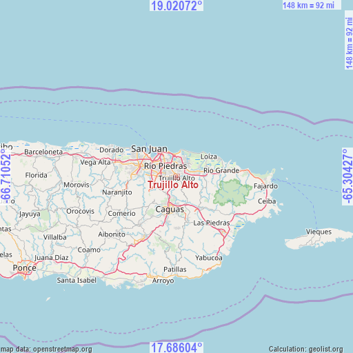
Trujillo Alto GPS coordinates[2]
18° 21' 16.812" North, 66° 0' 26.604" West
| Map corner | latitude | longitude |
|---|---|---|
| Upper-left | 19.02072°, | -66.71052° |
| Center: | 18.35467°, | -66.00739° |
| Lower-right: | 17.68604°, | -65.30427° |
| Map W x H: | 148.4×148.4 km | = 92.2×92.2mi |
| max Lat: | 18.50078° ⇑35.1% North |
| Trujillo Alto: | 18.35467° |
| min Lat: | ⇓64.9% South 17.95358° |
| min Long | Trujillo Alto | max Long |
| -67.2499° | -66.00739° | -65.30099° |
| W 75.6%⇐ | ⇒24.4% E |
Elevation
Elevation of Trujillo Alto is 21 m = 69 ft, and this is 79.5 m = 261 ft below average elevation for this country.
| Max E: |
655 m = 2149 ft | 69.8% |
| Avg. | 100.5 m = 330 ft | |
| Trujillo Alto | 21 m = 69 ft | |
Min E: |
1 m = 3 ft | 30.2% |
See also: Trujillo Alto elevation on elevation.city.
Geographical zone
Trujillo Alto is located in North Torrid zone (between Equator and Tropic of Cancer). Distance of this Northern Tropic circle is 565.1 km =351.1 mi to North.| Distance of | km | miles | from Trujillo Alto |
|---|---|---|---|
| North Pole | 7966.2 | 4950 | to North |
| Arctic Circle | 5360.3 | 3330.7 | to North |
| Tropic Cancer | 565.1 | 351.1 | to North |
| Equator | 2040.8 | 1268.1 | to South |


Nearby cities:
15 places around Trujillo Alto: (largest is in red/bold)
• Aguas Buenas
14.8 km =9.2 mi,  222°
222°
• Bairoa
11.2 km =7 mi,  198°
198°
• Caguas
14.1 km =8.8 mi, 197°
• Campo Rico
11.7 km =7.3 mi,  99°
99°
• Canovanas
11.6 km =7.2 mi,  78°
78°
• Carolina
6 km =3.7 mi,  61°
61°
• Cataño
15.2 km =9.4 mi,  309°
309°
• Celada
10.2 km =6.3 mi,  154°
154°
• Guaynabo
10.9 km =6.8 mi,  271°
271°
• Gurabo
11.7 km =7.3 mi,  161°
161°
• La Dolores
16.2 km =10.1 mi, 81°
• Lomas
14.1 km =8.8 mi,  132°
132°
• Loíza
15.9 km =9.9 mi, 57°
• San Isidro
13.5 km =8.4 mi,  72°
72°
• Santa Barbara
10.3 km =6.4 mi, 65°
Sources, notices
• [Note1] Compared only with cities in Puerto Rico existing in our database
• [Src1] Map data: © OpenStreetMap contributors (CC-BY-SA)
• [Src2] Other city data from geonames.org with taken over terms of usage.
• [Src3] Geographical zone / Annual Mean Temperature by Robert A. Rohde @ Wikipedia
