Santa Barbara geodata
Santa Barbara (Canóvanas) is a populated place; located in Puerto Rico in America/Puerto_Rico (GMT-4) time zone. With population of 5,168 people, there are 68 cities with bigger population in this country. Compared to other cities in Puerto Rico, 75.6% of cities are located further ↓South; 79.6% of cities are located further ←West and 73.8% of cities have higher elevation than Santa Barbara. Note1


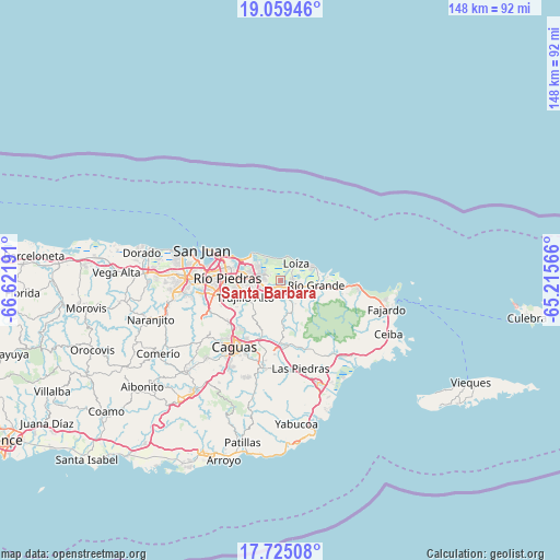
Santa Barbara GPS coordinates[2]
18° 23' 36.816" North, 65° 55' 7.608" West
| Map corner | latitude | longitude |
|---|---|---|
| Upper-left | 19.05946°, | -66.62191° |
| Center: | 18.39356°, | -65.91878° |
| Lower-right: | 17.72508°, | -65.21566° |
| Map W x H: | 148.4×148.4 km | = 92.2×92.2mi |
| max Lat: | 18.50078° ⇑24.4% North |
| Santa Barbara: | 18.39356° |
| min Lat: | ⇓75.6% South 17.95358° |
| min Long | Santa Barbara | max Long |
| -67.2499° | -65.91878° | -65.30099° |
| W 79.6%⇐ | ⇒20.4% E |
Elevation
Elevation of Santa Barbara is 18 m = 59 ft, and this is 82.5 m = 271 ft below average elevation for this country.
| Max E: |
655 m = 2149 ft | 73.8% |
| Avg. | 100.5 m = 330 ft | |
| Santa Barbara | 18 m = 59 ft | |
Min E: |
1 m = 3 ft | 26.2% |
See also: Puerto Rico elevation on elevation.city.
Geographical zone
Santa Barbara is located in North Torrid zone (between Equator and Tropic of Cancer). Distance of this Northern Tropic circle is 560.7 km =348.4 mi to North.| Distance of | km | miles | from Santa Barbara |
|---|---|---|---|
| North Pole | 7961.9 | 4947.3 | to North |
| Arctic Circle | 5356 | 3328.1 | to North |
| Tropic Cancer | 560.7 | 348.4 | to North |
| Equator | 2045.2 | 1270.8 | to South |


Nearby cities:
15 places around Santa Barbara: (largest is in red/bold)
• Bartolo
9.2 km =5.7 mi,  112°
112°
• Benitez
14 km =8.7 mi,  162°
162°
• Campo Rico
6.6 km =4.1 mi, 160°
• Canovanas
2.9 km =1.8 mi,  135°
135°
• Carolina
4.3 km =2.7 mi,  250°
250°
• Celada
14.4 km =8.9 mi,  200°
200°
• Hato Candal
14.1 km =8.8 mi,  98°
98°
• La Dolores
7 km =4.3 mi, 106°
• Lomas
13.9 km =8.6 mi,  175°
175°
• Loíza
5.9 km =3.7 mi,  44°
44°
• Río Grande
9.4 km =5.8 mi, 99°
• San Isidro
3.5 km =2.2 mi,  92°
92°
• Suárez
8 km =5 mi,  59°
59°
• Trujillo Alto
10.3 km =6.4 mi, 245°
• Vieques
9.7 km =6 mi,  68°
68°
Sources, notices
• [Note1] Compared only with cities in Puerto Rico existing in our database
• [Src1] Map data: © OpenStreetMap contributors (CC-BY-SA)
• [Src2] Other city data from geonames.org with taken over terms of usage.
• [Src3] Geographical zone / Annual Mean Temperature by Robert A. Rohde @ Wikipedia
