Las Ochenta geodata
Las Ochenta (Salinas) is a populated place; located in Puerto Rico in America/Puerto_Rico (GMT-4) time zone. With population of 1,199 people, there are 198 cities with bigger population in this country. Compared to other cities in Puerto Rico, 93.8% of cities are located further ↑North; 51.1% of cities are located further ←West and 81.3% of cities have higher elevation than Las Ochenta. Note1


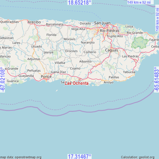
Las Ochenta GPS coordinates[2]
17° 59' 4.884" North, 66° 19' 4.62" West
| Map corner | latitude | longitude |
|---|---|---|
| Upper-left | 18.65218°, | -67.02108° |
| Center: | 17.98469°, | -66.31795° |
| Lower-right: | 17.31467°, | -65.61483° |
| Map W x H: | 148.7×148.7 km | = 92.4×92.4mi |
| max Lat: | 18.50078° ⇑93.8% North |
| Las Ochenta: | 17.98469° |
| min Lat: | ⇓6.2% South 17.95358° |
| min Long | Las Ochenta | max Long |
| -67.2499° | -66.31795° | -65.30099° |
| W 51.1%⇐ | ⇒48.9% E |
Elevation
Elevation of Las Ochenta is 14 m = 46 ft, and this is 86.5 m = 284 ft below average elevation for this country.
| Max E: |
655 m = 2149 ft | 81.3% |
| Avg. | 100.5 m = 330 ft | |
| Las Ochenta | 14 m = 46 ft | |
Min E: |
1 m = 3 ft | 18.7% |
See also: Puerto Rico elevation on elevation.city.
Geographical zone
Las Ochenta is located in North Torrid zone (between Equator and Tropic of Cancer). Distance of this Northern Tropic circle is 606.2 km =376.7 mi to North.| Distance of | km | miles | from Las Ochenta |
|---|---|---|---|
| North Pole | 8007.4 | 4975.6 | to North |
| Arctic Circle | 5401.5 | 3356.3 | to North |
| Tropic Cancer | 606.2 | 376.7 | to North |
| Equator | 1999.7 | 1242.6 | to South |


Nearby cities:
15 places around Las Ochenta: (largest is in red/bold)
• Central Aguirre
10.6 km =6.6 mi,  108°
108°
• Coamo
11.4 km =7.1 mi,  338°
338°
• Coco
6.7 km =4.2 mi,  68°
68°
• Coquí
9.7 km =6 mi,  96°
96°
• El Ojo
8.1 km =5 mi,  285°
285°
• Jauca
5.3 km =3.3 mi,  251°
251°
• Las Ollas
12.5 km =7.8 mi,  295°
295°
• Los Llanos
12.2 km =7.6 mi,  310°
310°
• Mariano Colón
4.6 km =2.9 mi, 340°
• Palmarejo
9.3 km =5.8 mi,  355°
355°
• Parcelas Peñuelas
2.9 km =1.8 mi, 302°
• Playita
4 km =2.5 mi,  131°
131°
• Salinas
2.3 km =1.4 mi, 110°
• Santa Isabel
9.4 km =5.8 mi,  257°
257°
• Vázquez
12.3 km =7.6 mi,  42°
42°
Sources, notices
• [Note1] Compared only with cities in Puerto Rico existing in our database
• [Src1] Map data: © OpenStreetMap contributors (CC-BY-SA)
• [Src2] Other city data from geonames.org with taken over terms of usage.
• [Src3] Geographical zone / Annual Mean Temperature by Robert A. Rohde @ Wikipedia
