Salinas geodata
Salinas is a seat of a first-order administrative division; located in Puerto Rico in America/Puerto_Rico (GMT-4) time zone. With population of 6,375 people, there are 53 cities with bigger population in this country. Compared to other cities in Puerto Rico, 95.6% of cities are located further ↑North; 52.9% of cities are located further ←West and 86.2% of cities have higher elevation than Salinas. Note1


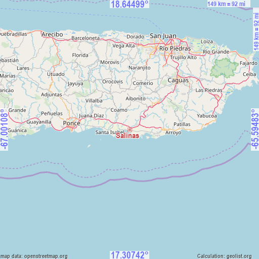
Salinas GPS coordinates[2]
17° 58' 38.892" North, 66° 17' 52.62" West
| Map corner | latitude | longitude |
|---|---|---|
| Upper-left | 18.64499°, | -67.00108° |
| Center: | 17.97747°, | -66.29795° |
| Lower-right: | 17.30742°, | -65.59483° |
| Map W x H: | 148.7×148.7 km | = 92.4×92.4mi |
| max Lat: | 18.50078° ⇑95.6% North |
| Salinas: | 17.97747° |
| min Lat: | ⇓4.4% South 17.95358° |
| min Long | Salinas | max Long |
| -67.2499° | -66.29795° | -65.30099° |
| W 52.9%⇐ | ⇒47.1% E |
Elevation
Elevation of Salinas is 9 m = 30 ft, and this is 91.5 m = 300 ft below average elevation for this country.
| Max E: |
655 m = 2149 ft | 86.2% |
| Avg. | 100.5 m = 330 ft | |
| Salinas | 9 m = 30 ft | |
Min E: |
1 m = 3 ft | 13.8% |
See also: Puerto Rico elevation on elevation.city.
Geographical zone
Salinas is located in North Torrid zone (between Equator and Tropic of Cancer). Distance of this Northern Tropic circle is 607 km =377.2 mi to North.| Distance of | km | miles | from Salinas |
|---|---|---|---|
| North Pole | 8008.2 | 4976.1 | to North |
| Arctic Circle | 5402.3 | 3356.8 | to North |
| Tropic Cancer | 607 | 377.2 | to North |
| Equator | 1998.9 | 1242.1 | to South |


Nearby cities:
15 places around Salinas: (largest is in red/bold)
• Central Aguirre
8.4 km =5.2 mi,  108°
108°
• Coamo
13 km =8.1 mi,  330°
330°
• Coco
5.3 km =3.3 mi,  51°
51°
• Coquí
7.5 km =4.7 mi,  92°
92°
• El Ojo
10.3 km =6.4 mi,  286°
286°
• Jauca
7.2 km =4.5 mi,  262°
262°
• Jobos
14.2 km =8.8 mi,  100°
100°
• La Plena
12.5 km =7.8 mi, 52°
• Las Ochenta
2.3 km =1.4 mi, 290°
• Mariano Colón
6.3 km =3.9 mi,  324°
324°
• Palmarejo
10.5 km =6.5 mi,  343°
343°
• Parcelas Peñuelas
5.2 km =3.2 mi,  297°
297°
• Playita
2.1 km =1.3 mi,  154°
154°
• Santa Isabel
11.4 km =7.1 mi, 263°
• Vázquez
11.7 km =7.3 mi,  32°
32°
Sources, notices
• [Note1] Compared only with cities in Puerto Rico existing in our database
• [Src1] Map data: © OpenStreetMap contributors (CC-BY-SA)
• [Src2] Other city data from geonames.org with taken over terms of usage.
• [Src3] Geographical zone / Annual Mean Temperature by Robert A. Rohde @ Wikipedia
