La Parguera geodata
La Parguera (Lajas) is a populated place; located in Puerto Rico in America/Puerto_Rico (GMT-4) time zone. With population of 1,141 people, there are 206 cities with bigger population in this country. Compared to other cities in Puerto Rico, 96% of cities are located further ↑North; 88.9% of cities are located further →East and 84% of cities have higher elevation than La Parguera. Note1


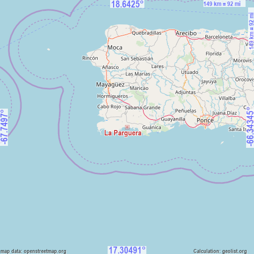
La Parguera GPS coordinates[2]
17° 58' 29.892" North, 67° 2' 47.652" West
| Map corner | latitude | longitude |
|---|---|---|
| Upper-left | 18.6425°, | -67.7497° |
| Center: | 17.97497°, | -67.04657° |
| Lower-right: | 17.30491°, | -66.34345° |
| Map W x H: | 148.7×148.7 km | = 92.4×92.4mi |
| max Lat: | 18.50078° ⇑96% North |
| La Parguera: | 17.97497° |
| min Lat: | ⇓4% South 17.95358° |
| min Long | La Parguera | max Long |
| -67.2499° | -67.04657° | -65.30099° |
| W 11.1%⇐ | ⇒88.9% E |
Elevation
Elevation of La Parguera is 11 m = 36 ft, and this is 89.5 m = 294 ft below average elevation for this country.
| Max E: |
655 m = 2149 ft | 84% |
| Avg. | 100.5 m = 330 ft | |
| La Parguera | 11 m = 36 ft | |
Min E: |
1 m = 3 ft | 16% |
See also: Puerto Rico elevation on elevation.city.
Geographical zone
La Parguera is located in North Torrid zone (between Equator and Tropic of Cancer). Distance of this Northern Tropic circle is 607.3 km =377.4 mi to North.| Distance of | km | miles | from La Parguera |
|---|---|---|---|
| North Pole | 8008.4 | 4976.2 | to North |
| Arctic Circle | 5402.5 | 3357 | to North |
| Tropic Cancer | 607.3 | 377.4 | to North |
| Equator | 1998.6 | 1241.9 | to South |


Nearby cities:
15 places around La Parguera: (largest is in red/bold)
• Betances
11.1 km =6.9 mi,  302°
302°
• Boquerón
14.2 km =8.8 mi,  294°
294°
• Cabo Rojo
16.2 km =10.1 mi,  319°
319°
• Fuig
13.9 km =8.6 mi,  84°
84°
• Guánica
14.7 km =9.1 mi,  91°
91°
• Lajas
8.4 km =5.2 mi,  350°
350°
• Liborio Negron Torres
13.4 km =8.3 mi,  55°
55°
• Lluveras
16.6 km =10.3 mi, 64°
• Maria Antonia
16.6 km =10.3 mi, 88°
• Monte Grande
14.1 km =8.8 mi,  332°
332°
• Palmarejo
7.9 km =4.9 mi,  336°
336°
• Pole Ojea
14.7 km =9.1 mi,  269°
269°
• Sabana Eneas
12.9 km =8 mi, 343°
• Sabana Grande
14.6 km =9.1 mi,  38°
38°
• San Germán
11.9 km =7.4 mi,  0°
0°
Sources, notices
• [Note1] Compared only with cities in Puerto Rico existing in our database
• [Src1] Map data: © OpenStreetMap contributors (CC-BY-SA)
• [Src2] Other city data from geonames.org with taken over terms of usage.
• [Src3] Geographical zone / Annual Mean Temperature by Robert A. Rohde @ Wikipedia
