Sabana Grande geodata
Sabana Grande is a seat of a first-order administrative division; located in Puerto Rico in America/Puerto_Rico (GMT-4) time zone. With population of 8,961 people, there are 38 cities with bigger population in this country. Compared to other cities in Puerto Rico, 71.1% of cities are located further ↑North; 85.3% of cities are located further →East and 70.7% of cities have lower elevation than Sabana Grande. Note1


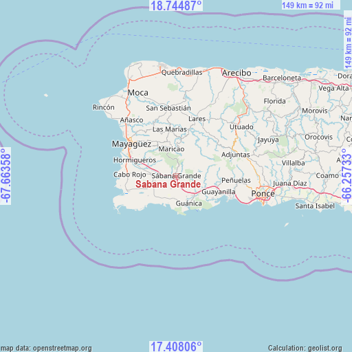
Sabana Grande GPS coordinates[2]
18° 4' 39.864" North, 66° 57' 37.62" West
| Map corner | latitude | longitude |
|---|---|---|
| Upper-left | 18.74487°, | -67.66358° |
| Center: | 18.07774°, | -66.96045° |
| Lower-right: | 17.40806°, | -66.25733° |
| Map W x H: | 148.6×148.6 km | = 92.3×92.3mi |
| max Lat: | 18.50078° ⇑71.1% North |
| Sabana Grande: | 18.07774° |
| min Lat: | ⇓28.9% South 17.95358° |
| min Long | Sabana Grande | max Long |
| -67.2499° | -66.96045° | -65.30099° |
| W 14.7%⇐ | ⇒85.3% E |
Elevation
Elevation of Sabana Grande is 98 m = 322 ft, and this is 2.5 m = 8 ft below average elevation for this country.
| Max E: |
655 m = 2149 ft | 29.3% |
| Avg. | 100.5 m = 330 ft | |
| Sabana Grande | 98 m = 322 ft | |
Min E: |
1 m = 3 ft | 70.7% |
See also: Puerto Rico elevation on elevation.city.
Geographical zone
Sabana Grande is located in North Torrid zone (between Equator and Tropic of Cancer). Distance of this Northern Tropic circle is 595.9 km =370.3 mi to North.| Distance of | km | miles | from Sabana Grande |
|---|---|---|---|
| North Pole | 7997 | 4969.1 | to North |
| Arctic Circle | 5391.1 | 3349.9 | to North |
| Tropic Cancer | 595.9 | 370.3 | to North |
| Equator | 2010.1 | 1249 | to South |


Nearby cities:
15 places around Sabana Grande: (largest is in red/bold)
• Fuig
11.1 km =6.9 mi,  154°
154°
• Guánica
13 km =8.1 mi, 154°
• Indios
17.6 km =10.9 mi,  121°
121°
• La Parguera
14.6 km =9.1 mi,  218°
218°
• Lajas
10.9 km =6.8 mi,  253°
253°
• Liborio Negron Torres
4.3 km =2.7 mi, 153°
• Lluveras
7.4 km =4.6 mi,  126°
126°
• Maria Antonia
13.4 km =8.3 mi, 145°
• Maricao
11.6 km =7.2 mi,  349°
349°
• Monte Grande
15.6 km =9.7 mi,  273°
273°
• Palmarejo
13 km =8.1 mi, 251°
• Palomas
11.7 km =7.3 mi, 127°
• Sabana Eneas
12.8 km =8 mi, 274°
• San Germán
8.9 km =5.5 mi, 272°
• Yauco
12.6 km =7.8 mi,  112°
112°
Sources, notices
• [Note1] Compared only with cities in Puerto Rico existing in our database
• [Src1] Map data: © OpenStreetMap contributors (CC-BY-SA)
• [Src2] Other city data from geonames.org with taken over terms of usage.
• [Src3] Geographical zone / Annual Mean Temperature by Robert A. Rohde @ Wikipedia
