Lluveras geodata
Lluveras (Sabana Grande) is a populated place; located in Puerto Rico in America/Puerto_Rico (GMT-4) time zone. With population of 2,005 people, there are 141 cities with bigger population in this country. Compared to other cities in Puerto Rico, 80.4% of cities are located further ↑North; 81.8% of cities are located further →East and 71.6% of cities have lower elevation than Lluveras. Note1


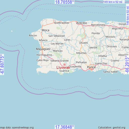
Lluveras GPS coordinates[2]
18° 2' 17.88" North, 66° 54' 16.632" West
| Map corner | latitude | longitude |
|---|---|---|
| Upper-left | 18.70558°, | -67.60775° |
| Center: | 18.0383°, | -66.90462° |
| Lower-right: | 17.36848°, | -66.2015° |
| Map W x H: | 148.7×148.7 km | = 92.4×92.4mi |
| max Lat: | 18.50078° ⇑80.4% North |
| Lluveras: | 18.0383° |
| min Lat: | ⇓19.6% South 17.95358° |
| min Long | Lluveras | max Long |
| -67.2499° | -66.90462° | -65.30099° |
| W 18.2%⇐ | ⇒81.8% E |
Elevation
Elevation of Lluveras is 100 m = 328 ft, and this is 0.5 m = 2 ft below average elevation for this country.
| Max E: |
655 m = 2149 ft | 28.4% |
| Avg. | 100.5 m = 330 ft | |
| Lluveras | 100 m = 328 ft | |
Min E: |
1 m = 3 ft | 71.6% |
See also: Puerto Rico elevation on elevation.city.
Geographical zone
Lluveras is located in North Torrid zone (between Equator and Tropic of Cancer). Distance of this Northern Tropic circle is 600.2 km =372.9 mi to North.| Distance of | km | miles | from Lluveras |
|---|---|---|---|
| North Pole | 8001.4 | 4971.8 | to North |
| Arctic Circle | 5395.5 | 3352.6 | to North |
| Tropic Cancer | 600.2 | 372.9 | to North |
| Equator | 2005.7 | 1246.3 | to South |


Nearby cities:
15 places around Lluveras: (largest is in red/bold)
• Fuig
5.7 km =3.5 mi,  192°
192°
• Guayanilla
12.1 km =7.5 mi,  100°
100°
• Guánica
7.4 km =4.6 mi,  182°
182°
• Indios
10.3 km =6.4 mi,  118°
118°
• La Parguera
16.6 km =10.3 mi,  244°
244°
• Lajas
16.4 km =10.2 mi,  274°
274°
• Liborio Negron Torres
4 km =2.5 mi,  277°
277°
• Magas Arriba
14.5 km =9 mi, 99°
• Maria Antonia
6.9 km =4.3 mi,  166°
166°
• Maricao
17.7 km =11 mi,  333°
333°
• Palomas
4.3 km =2.7 mi,  129°
129°
• Sabana Grande
7.4 km =4.6 mi,  306°
306°
• San Germán
15.6 km =9.7 mi,  287°
287°
• Santo Domingo
16.3 km =10.1 mi,  80°
80°
• Yauco
5.8 km =3.6 mi,  93°
93°
Sources, notices
• [Note1] Compared only with cities in Puerto Rico existing in our database
• [Src1] Map data: © OpenStreetMap contributors (CC-BY-SA)
• [Src2] Other city data from geonames.org with taken over terms of usage.
• [Src3] Geographical zone / Annual Mean Temperature by Robert A. Rohde @ Wikipedia
