Jayuya geodata
Jayuya is a seat of a first-order administrative division; located in Puerto Rico in America/Puerto_Rico (GMT-4) time zone. With population of 3,587 people, there are 90 cities with bigger population in this country. Compared to other cities in Puerto Rico, 54.2% of cities are located further ↑North; 68.4% of cities are located further →East and 95.1% of cities have lower elevation than Jayuya. Note1


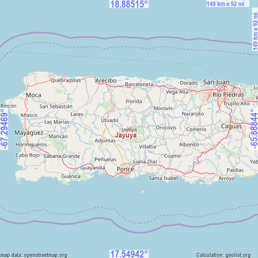
Jayuya GPS coordinates[2]
18° 13' 6.852" North, 66° 35' 29.616" West
| Map corner | latitude | longitude |
|---|---|---|
| Upper-left | 18.88515°, | -67.29469° |
| Center: | 18.21857°, | -66.59156° |
| Lower-right: | 17.54942°, | -65.88844° |
| Map W x H: | 148.5×148.5 km | = 92.3×92.3mi |
| max Lat: | 18.50078° ⇑54.2% North |
| Jayuya: | 18.21857° |
| min Lat: | ⇓45.8% South 17.95358° |
| min Long | Jayuya | max Long |
| -67.2499° | -66.59156° | -65.30099° |
| W 31.6%⇐ | ⇒68.4% E |
Elevation
Elevation of Jayuya is 441 m = 1447 ft, and this is 340.5 m = 1117 ft above average elevation for this country.
| Max E: |
655 m = 2149 ft | 4.9% |
| Jayuya | 441 m 1447 ft | |
| Avg. | 100.5 m = 330 ft | |
Min E: |
1 m = 3 ft | 95.1% |
See also: Puerto Rico elevation on elevation.city.
Geographical zone
Jayuya is located in North Torrid zone (between Equator and Tropic of Cancer). Distance of this Northern Tropic circle is 580.2 km =360.5 mi to North.| Distance of | km | miles | from Jayuya |
|---|---|---|---|
| North Pole | 7981.3 | 4959.3 | to North |
| Arctic Circle | 5375.5 | 3340.2 | to North |
| Tropic Cancer | 580.2 | 360.5 | to North |
| Equator | 2025.7 | 1258.7 | to South |


Nearby cities:
15 places around Jayuya: (largest is in red/bold)
• Adjuntas
15.1 km =9.4 mi,  245°
245°
• Cayuco
17.6 km =10.9 mi,  297°
297°
• Ciales
18.4 km =11.4 mi,  44°
44°
• Coto Laurel
19.3 km =12 mi,  167°
167°
• Estancias de Florida
16.6 km =10.3 mi,  8°
8°
• Florida
16.3 km =10.1 mi, 11°
• Guayabal
18 km =11.2 mi,  147°
147°
• Juana Díaz
20.5 km =12.7 mi, 154°
• La Alianza
19.9 km =12.4 mi,  356°
356°
• Luis Llorens Torres
19.2 km =11.9 mi,  159°
159°
• Marueño
19.1 km =11.9 mi,  200°
200°
• Orocovis
21.2 km =13.2 mi,  87°
87°
• Pajonal
18.6 km =11.6 mi, 11°
• Utuado
12.6 km =7.8 mi,  294°
294°
• Villalba
14.6 km =9.1 mi,  134°
134°
Sources, notices
• [Note1] Compared only with cities in Puerto Rico existing in our database
• [Src1] Map data: © OpenStreetMap contributors (CC-BY-SA)
• [Src2] Other city data from geonames.org with taken over terms of usage.
• [Src3] Geographical zone / Annual Mean Temperature by Robert A. Rohde @ Wikipedia
