Ventosa geodata
Ventosa (Lisbon) is a populated place; located in Portugal in Europe/Lisbon (GMT+1) time zone. With population of 5,215 people, there are 407 cities with bigger population in this country. Compared to other cities in Portugal, 61.8% of cities are located further ↑North; 77% of cities are located further →East and 56% of cities have lower elevation than Ventosa. Note1


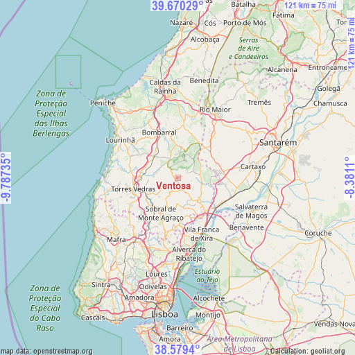
Ventosa GPS coordinates[2]
39° 7' 37.056" North, 9° 5' 3.228" West
| Map corner | latitude | longitude |
|---|---|---|
| Upper-left | 39.67029°, | -9.78735° |
| Center: | 39.12696°, | -9.08423° |
| Lower-right: | 38.5794°, | -8.3811° |
| Map W x H: | 121.3×121.3 km | = 75.4×75.4mi |
| max Lat: | 42.11337° ⇑61.8% North |
| Ventosa: | 39.12696° |
| min Lat: | ⇓38.2% South 32.6448° |
| min Long | Ventosa | max Long |
| -31.17847° | -9.08423° | -6.27308° |
| W 23%⇐ | ⇒77% E |
Elevation
Elevation of Ventosa is 133 m = 436 ft, and this is 44 m = 144 ft below average elevation for this country.
| Max E: |
1008 m = 3307 ft | 44% |
| Avg. | 177 m = 581 ft | |
| Ventosa | 133 m = 436 ft | |
Min E: |
-128 m = -420 ft | 56% |
See also: Portugal elevation on elevation.city.
Geographical zone
Ventosa is located in North temperate zone (between Tropic of Cancer and the Arctic Circle). Distance of this Northern Tropic circle is 1744.6 km =1084 mi to South.| Distance of | km | miles | from Ventosa |
|---|---|---|---|
| North Pole | 5656.6 | 3514.8 | to North |
| Arctic Circle | 3050.7 | 1895.6 | to North |
| Tropic Cancer | 1744.6 | 1084 | to South |
| Equator | 4350.5 | 2703.3 | to South |


Nearby cities:
15 places around Ventosa: (largest is in red/bold)
• Abrigada
6 km =3.7 mi,  71°
71°
• Alcoentre
14.1 km =8.8 mi,  49°
49°
• Alenquer
10.4 km =6.5 mi,  141°
141°
• Arruda dos Vinhos
15.9 km =9.9 mi,  177°
177°
• Cabanas de Torres
3.6 km =2.2 mi,  26°
26°
• Cadafais
15.3 km =9.5 mi,  153°
153°
• Cadaval
13 km =8.1 mi,  352°
352°
• Campelos
15.2 km =9.4 mi,  300°
300°
• Carregado
14.8 km =9.2 mi, 141°
• Meca
6.6 km =4.1 mi, 139°
• Ota
8.2 km =5.1 mi,  101°
101°
• Pereiro da Palhacana
9.6 km =6 mi,  193°
193°
• Sobral de Monte Agraço
13.3 km =8.3 mi,  205°
205°
• Torres Vedras
15.6 km =9.7 mi,  255°
255°
• Vila Verde
4.1 km =2.5 mi,  319°
319°
Sources, notices
• [Note1] Compared only with cities in Portugal existing in our database
• [Src1] Map data: © OpenStreetMap contributors (CC-BY-SA)
• [Src2] Other city data from geonames.org with taken over terms of usage.
• [Src3] Geographical zone / Annual Mean Temperature by Robert A. Rohde @ Wikipedia
