Cadaval geodata
Cadaval (Lisbon) is a seat of a second-order administrative division; located in Portugal in Europe/Lisbon (GMT+1) time zone. With population of 2,500 people, there are 617 cities with bigger population in this country. Compared to other cities in Portugal, 59.4% of cities are located further ↑North; 78.1% of cities are located further →East and 51.9% of cities have higher elevation than Cadaval. Note1


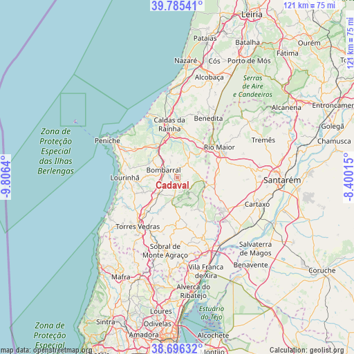
Cadaval GPS coordinates[2]
39° 14' 34.728" North, 9° 6' 11.772" West
| Map corner | latitude | longitude |
|---|---|---|
| Upper-left | 39.78541°, | -9.8064° |
| Center: | 39.24298°, | -9.10327° |
| Lower-right: | 38.69632°, | -8.40015° |
| Map W x H: | 121.1×121.1 km | = 75.2×75.2mi |
| max Lat: | 42.11337° ⇑59.4% North |
| Cadaval: | 39.24298° |
| min Lat: | ⇓40.6% South 32.6448° |
| min Long | Cadaval | max Long |
| -31.17847° | -9.10327° | -6.27308° |
| W 21.9%⇐ | ⇒78.1% E |
Elevation
Elevation of Cadaval is 105 m = 344 ft, and this is 72 m = 236 ft below average elevation for this country.
| Max E: |
1008 m = 3307 ft | 51.9% |
| Avg. | 177 m = 581 ft | |
| Cadaval | 105 m = 344 ft | |
Min E: |
-128 m = -420 ft | 48.1% |
See also: Portugal elevation on elevation.city.
Geographical zone
Cadaval is located in North temperate zone (between Tropic of Cancer and the Arctic Circle). Distance of this Northern Tropic circle is 1757.5 km =1092.1 mi to South.| Distance of | km | miles | from Cadaval |
|---|---|---|---|
| North Pole | 5643.7 | 3506.8 | to North |
| Arctic Circle | 3037.8 | 1887.6 | to North |
| Tropic Cancer | 1757.5 | 1092.1 | to South |
| Equator | 4363.4 | 2711.3 | to South |


Nearby cities:
15 places around Cadaval: (largest is in red/bold)
• A dos Francos
10.1 km =6.3 mi,  28°
28°
• Abrigada
13.2 km =8.2 mi,  146°
146°
• Alcoentre
13 km =8.1 mi,  107°
107°
• Alvorninha
16.5 km =10.3 mi,  20°
20°
• Bombarral
5.4 km =3.4 mi,  299°
299°
• Cabanas de Torres
10.2 km =6.3 mi,  161°
161°
• Campelos
12.5 km =7.8 mi,  245°
245°
• Moita dos Ferreiros
10.4 km =6.5 mi,  273°
273°
• Ota
17.5 km =10.9 mi, 146°
• Serra de El-Rei
17.4 km =10.8 mi,  305°
305°
• São Bartolomeu
15.5 km =9.6 mi,  283°
283°
• Ventosa
13 km =8.1 mi,  172°
172°
• Vidais
14.8 km =9.2 mi, 18°
• Vila Verde
9.8 km =6.1 mi,  185°
185°
• Óbidos
13.9 km =8.6 mi,  340°
340°
Sources, notices
• [Note1] Compared only with cities in Portugal existing in our database
• [Src1] Map data: © OpenStreetMap contributors (CC-BY-SA)
• [Src2] Other city data from geonames.org with taken over terms of usage.
• [Src3] Geographical zone / Annual Mean Temperature by Robert A. Rohde @ Wikipedia
