Trafaria geodata
Trafaria (District of Setúbal) is a populated place; located in Portugal in Europe/Lisbon (GMT+1) time zone. With population of 5,603 people, there are 387 cities with bigger population in this country. Compared to other cities in Portugal, 76.2% of cities are located further ↑North; 83.9% of cities are located further →East and 93.2% of cities have higher elevation than Trafaria. Note1


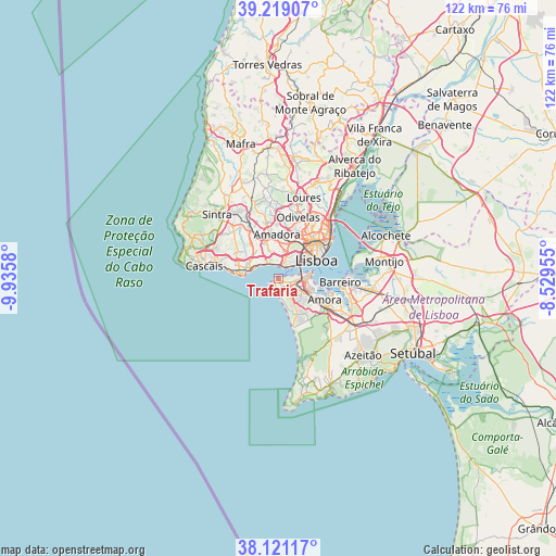
Trafaria GPS coordinates[2]
38° 40' 19.992" North, 9° 13' 57.648" West
| Map corner | latitude | longitude |
|---|---|---|
| Upper-left | 39.21907°, | -9.9358° |
| Center: | 38.67222°, | -9.23268° |
| Lower-right: | 38.12117°, | -8.52955° |
| Map W x H: | 122.1×122.1 km | = 75.9×75.9mi |
| max Lat: | 42.11337° ⇑76.2% North |
| Trafaria: | 38.67222° |
| min Lat: | ⇓23.8% South 32.6448° |
| min Long | Trafaria | max Long |
| -31.17847° | -9.23268° | -6.27308° |
| W 16.1%⇐ | ⇒83.9% E |
Elevation
Elevation of Trafaria is 12 m = 39 ft, and this is 165 m = 541 ft below average elevation for this country.
| Max E: |
1008 m = 3307 ft | 93.2% |
| Avg. | 177 m = 581 ft | |
| Trafaria | 12 m = 39 ft | |
Min E: |
-128 m = -420 ft | 6.8% |
See also: Portugal elevation on elevation.city.
Geographical zone
Trafaria is located in North temperate zone (between Tropic of Cancer and the Arctic Circle). Distance of this Northern Tropic circle is 1694 km =1052.6 mi to South.| Distance of | km | miles | from Trafaria |
|---|---|---|---|
| North Pole | 5707.1 | 3546.2 | to North |
| Arctic Circle | 3101.2 | 1927 | to North |
| Tropic Cancer | 1694 | 1052.6 | to South |
| Equator | 4299.9 | 2671.8 | to South |


Nearby cities:
15 places around Trafaria: (largest is in red/bold)
• Alfragide
6.8 km =4.2 mi,  9°
9°
• Algés
3.4 km =2.1 mi,  4°
4°
• Almada
6.6 km =4.1 mi,  83°
83°
• Caparica
3 km =1.9 mi,  112°
112°
• Carnaxide
6.2 km =3.9 mi,  348°
348°
• Caxias
5.1 km =3.2 mi,  312°
312°
• Charneca de Caparica
6.7 km =4.2 mi,  149°
149°
• Costa de Caparica
3.1 km =1.9 mi,  184°
184°
• Linda-a-Velha
4.8 km =3 mi, 350°
• Paço de Arcos
5.7 km =3.5 mi,  297°
297°
• Piedade
6.4 km =4 mi,  92°
92°
• Pragal
5.5 km =3.4 mi, 87°
• Queijas
5.8 km =3.6 mi,  333°
333°
• Sobreda
4.5 km =2.8 mi,  124°
124°
• Terrugem
6.1 km =3.8 mi, 308°
Sources, notices
• [Note1] Compared only with cities in Portugal existing in our database
• [Src1] Map data: © OpenStreetMap contributors (CC-BY-SA)
• [Src2] Other city data from geonames.org with taken over terms of usage.
• [Src3] Geographical zone / Annual Mean Temperature by Robert A. Rohde @ Wikipedia
