Algés geodata
Algés (Lisbon) is a populated place; located in Portugal in Europe/Lisbon (GMT+1) time zone. With population of 19,327 people, there are 102 cities with bigger population in this country. Compared to other cities in Portugal, 74.1% of cities are located further ↑North; 83.6% of cities are located further →East and 90.3% of cities have higher elevation than Algés. Note1


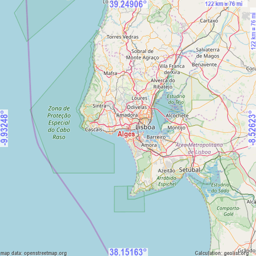
Algés GPS coordinates[2]
38° 42' 8.82" North, 9° 13' 45.696" West
| Map corner | latitude | longitude |
|---|---|---|
| Upper-left | 39.24906°, | -9.93248° |
| Center: | 38.70245°, | -9.22936° |
| Lower-right: | 38.15163°, | -8.52623° |
| Map W x H: | 122×122 km | = 75.8×75.8mi |
| max Lat: | 42.11337° ⇑74.1% North |
| Algés: | 38.70245° |
| min Lat: | ⇓25.9% South 32.6448° |
| min Long | Algés | max Long |
| -31.17847° | -9.22936° | -6.27308° |
| W 16.4%⇐ | ⇒83.6% E |
Elevation
Elevation of Algés is 16 m = 52 ft, and this is 161 m = 528 ft below average elevation for this country.
| Max E: |
1008 m = 3307 ft | 90.3% |
| Avg. | 177 m = 581 ft | |
| Algés | 16 m = 52 ft | |
Min E: |
-128 m = -420 ft | 9.7% |
See also: Portugal elevation on elevation.city.
Geographical zone
Algés is located in North temperate zone (between Tropic of Cancer and the Arctic Circle). Distance of this Northern Tropic circle is 1697.4 km =1054.7 mi to South.| Distance of | km | miles | from Algés |
|---|---|---|---|
| North Pole | 5703.8 | 3544.2 | to North |
| Arctic Circle | 3097.9 | 1924.9 | to North |
| Tropic Cancer | 1697.4 | 1054.7 | to South |
| Equator | 4303.3 | 2673.9 | to South |


Nearby cities:
15 places around Algés: (largest is in red/bold)
• Alfragide
3.4 km =2.1 mi,  15°
15°
• Amadora
5.7 km =3.5 mi,  358°
358°
• Barcarena
5.5 km =3.4 mi,  307°
307°
• Benfica
5.9 km =3.7 mi, 23°
• Caparica
5.2 km =3.2 mi,  150°
150°
• Carnaxide
3.1 km =1.9 mi,  331°
331°
• Caxias
4.1 km =2.5 mi,  271°
271°
• Linda-a-Velha
1.7 km =1.1 mi,  320°
320°
• Paço de Arcos
5.4 km =3.4 mi,  262°
262°
• Pragal
6 km =3.7 mi,  120°
120°
• Queijas
3.4 km =2.1 mi,  302°
302°
• Queluz
6.4 km =4 mi,  340°
340°
• Santos-o-Velho
6.4 km =4 mi,  85°
85°
• Terrugem
5 km =3.1 mi,  275°
275°
• Trafaria
3.4 km =2.1 mi,  184°
184°
Sources, notices
• [Note1] Compared only with cities in Portugal existing in our database
• [Src1] Map data: © OpenStreetMap contributors (CC-BY-SA)
• [Src2] Other city data from geonames.org with taken over terms of usage.
• [Src3] Geographical zone / Annual Mean Temperature by Robert A. Rohde @ Wikipedia
