Alfragide geodata
Alfragide (Lisbon) is a populated locality; located in Portugal in Europe/Lisbon (GMT+1) time zone. With population of 17,044 people, there are 124 cities with bigger population in this country. Compared to other cities in Portugal, 72.3% of cities are located further ↑North; 83.3% of cities are located further →East and 54.5% of cities have lower elevation than Alfragide. Note1


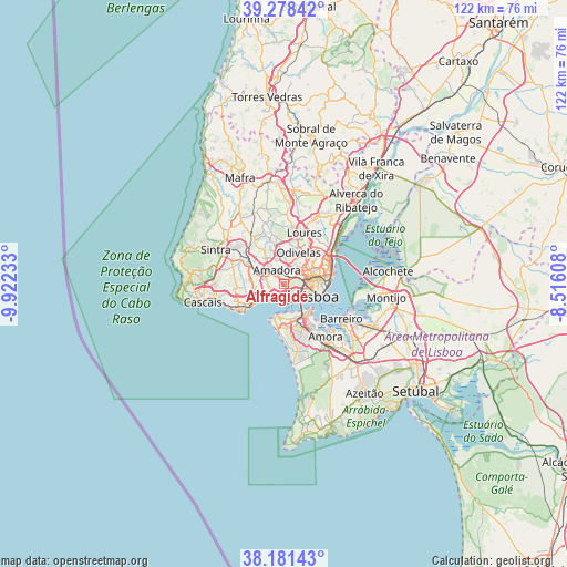
Alfragide GPS coordinates[2]
38° 43' 55.308" North, 9° 13' 9.12" West
| Map corner | latitude | longitude |
|---|---|---|
| Upper-left | 39.27842°, | -9.92233° |
| Center: | 38.73203°, | -9.2192° |
| Lower-right: | 38.18143°, | -8.51608° |
| Map W x H: | 122×122 km | = 75.8×75.8mi |
| max Lat: | 42.11337° ⇑72.3% North |
| Alfragide: | 38.73203° |
| min Lat: | ⇓27.7% South 32.6448° |
| min Long | Alfragide | max Long |
| -31.17847° | -9.2192° | -6.27308° |
| W 16.7%⇐ | ⇒83.3% E |
Elevation
Elevation of Alfragide is 127 m = 417 ft, and this is 50 m = 164 ft below average elevation for this country.
| Max E: |
1008 m = 3307 ft | 45.5% |
| Avg. | 177 m = 581 ft | |
| Alfragide | 127 m = 417 ft | |
Min E: |
-128 m = -420 ft | 54.5% |
See also: Portugal elevation on elevation.city.
Geographical zone
Alfragide is located in North temperate zone (between Tropic of Cancer and the Arctic Circle). Distance of this Northern Tropic circle is 1700.7 km =1056.8 mi to South.| Distance of | km | miles | from Alfragide |
|---|---|---|---|
| North Pole | 5700.5 | 3542.1 | to North |
| Arctic Circle | 3094.6 | 1922.9 | to North |
| Tropic Cancer | 1700.7 | 1056.8 | to South |
| Equator | 4306.6 | 2676 | to South |


Nearby cities:
15 places around Alfragide: (largest is in red/bold)
• Algés
3.4 km =2.1 mi,  195°
195°
• Amadora
2.6 km =1.6 mi,  337°
337°
• Barcarena
5.3 km =3.3 mi,  270°
270°
• Belas
6.3 km =3.9 mi,  322°
322°
• Benfica
2.5 km =1.6 mi,  34°
34°
• Carnaxide
2.4 km =1.5 mi,  256°
256°
• Caxias
5.9 km =3.7 mi,  237°
237°
• Famões
6.3 km =3.9 mi,  7°
7°
• Linda-a-Velha
2.8 km =1.7 mi,  225°
225°
• Massamá
5.8 km =3.6 mi,  293°
293°
• Pontinha
4.3 km =2.7 mi,  23°
23°
• Queijas
4 km =2.5 mi,  249°
249°
• Queluz
4.1 km =2.5 mi,  311°
311°
• Santos-o-Velho
6.1 km =3.8 mi,  117°
117°
• Terrugem
6.5 km =4 mi, 244°
Sources, notices
• [Note1] Compared only with cities in Portugal existing in our database
• [Src1] Map data: © OpenStreetMap contributors (CC-BY-SA)
• [Src2] Other city data from geonames.org with taken over terms of usage.
• [Src3] Geographical zone / Annual Mean Temperature by Robert A. Rohde @ Wikipedia
