Bucelas geodata
Bucelas (Lisbon) is a populated place; located in Portugal in Europe/Lisbon (GMT+1) time zone. With population of 4,614 people, there are 460 cities with bigger population in this country. Compared to other cities in Portugal, 66.4% of cities are located further ↑North; 79% of cities are located further →East and 55.5% of cities have higher elevation than Bucelas. Note1


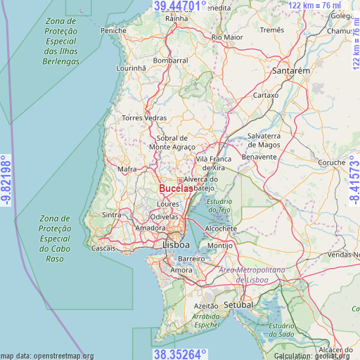
Bucelas GPS coordinates[2]
38° 54' 6.948" North, 9° 7' 7.86" West
| Map corner | latitude | longitude |
|---|---|---|
| Upper-left | 39.44701°, | -9.82198° |
| Center: | 38.90193°, | -9.11885° |
| Lower-right: | 38.35264°, | -8.41573° |
| Map W x H: | 121.7×121.7 km | = 75.6×75.6mi |
| max Lat: | 42.11337° ⇑66.4% North |
| Bucelas: | 38.90193° |
| min Lat: | ⇓33.6% South 32.6448° |
| min Long | Bucelas | max Long |
| -31.17847° | -9.11885° | -6.27308° |
| W 21%⇐ | ⇒79% E |
Elevation
Elevation of Bucelas is 91 m = 299 ft, and this is 86 m = 282 ft below average elevation for this country.
| Max E: |
1008 m = 3307 ft | 55.5% |
| Avg. | 177 m = 581 ft | |
| Bucelas | 91 m = 299 ft | |
Min E: |
-128 m = -420 ft | 44.5% |
See also: Portugal elevation on elevation.city.
Geographical zone
Bucelas is located in North temperate zone (between Tropic of Cancer and the Arctic Circle). Distance of this Northern Tropic circle is 1719.6 km =1068.5 mi to South.| Distance of | km | miles | from Bucelas |
|---|---|---|---|
| North Pole | 5681.6 | 3530.4 | to North |
| Arctic Circle | 3075.7 | 1911.2 | to North |
| Tropic Cancer | 1719.6 | 1068.5 | to South |
| Equator | 4325.5 | 2687.7 | to South |


Nearby cities:
15 places around Bucelas: (largest is in red/bold)
• Alhandra
9.9 km =6.2 mi,  73°
73°
• Apelação
9.9 km =6.2 mi,  186°
186°
• Arranhó
5.9 km =3.7 mi,  346°
346°
• Arruda dos Vinhos
9.8 km =6.1 mi,  21°
21°
• Loures
9 km =5.6 mi,  208°
208°
• Milharado
8.6 km =5.3 mi,  306°
306°
• Póvoa de Santa Iria
6.5 km =4 mi,  134°
134°
• Santa Iria da Azóia
7 km =4.3 mi,  165°
165°
• Santo Antão do Tojal
5.9 km =3.7 mi,  197°
197°
• Sobralinho
8.2 km =5.1 mi,  78°
78°
• São João da Talha
8.9 km =5.5 mi, 167°
• São João dos Montes
9.6 km =6 mi,  64°
64°
• Unhos
9.2 km =5.7 mi,  180°
180°
• Venda do Pinheiro
10.1 km =6.3 mi,  283°
283°
• Vialonga
4.8 km =3 mi, 133°
Sources, notices
• [Note1] Compared only with cities in Portugal existing in our database
• [Src1] Map data: © OpenStreetMap contributors (CC-BY-SA)
• [Src2] Other city data from geonames.org with taken over terms of usage.
• [Src3] Geographical zone / Annual Mean Temperature by Robert A. Rohde @ Wikipedia
