Serpa geodata
Serpa (Beja) is a seat of a second-order administrative division; located in Portugal in Europe/Lisbon (GMT+1) time zone. With population of 6,586 people, there are 335 cities with bigger population in this country. Compared to other cities in Portugal, 84.6% of cities are located further ↑North; 89.9% of cities are located further ←West and 69.1% of cities have lower elevation than Serpa. Note1


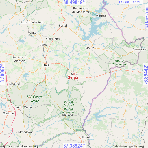
Serpa GPS coordinates[2]
37° 56' 44.916" North, 7° 35' 51.144" West
| Map corner | latitude | longitude |
|---|---|---|
| Upper-left | 38.49819°, | -8.30067° |
| Center: | 37.94581°, | -7.59754° |
| Lower-right: | 37.38924°, | -6.89442° |
| Map W x H: | 123.3×123.3 km | = 76.6×76.6mi |
| max Lat: | 42.11337° ⇑84.6% North |
| Serpa: | 37.94581° |
| min Lat: | ⇓15.4% South 32.6448° |
| min Long | Serpa | max Long |
| -31.17847° | -7.59754° | -6.27308° |
| W 89.9%⇐ | ⇒10.1% E |
Elevation
Elevation of Serpa is 198 m = 650 ft, and this is 21 m = 69 ft above average elevation for this country.
| Max E: |
1008 m = 3307 ft | 30.9% |
| Serpa | 198 m 650 ft | |
| Avg. | 177 m = 581 ft | |
Min E: |
-128 m = -420 ft | 69.1% |
See also: Portugal elevation on elevation.city.
Geographical zone
Serpa is located in North temperate zone (between Tropic of Cancer and the Arctic Circle). Distance of this Northern Tropic circle is 1613.3 km =1002.5 mi to South.| Distance of | km | miles | from Serpa |
|---|---|---|---|
| North Pole | 5787.9 | 3596.4 | to North |
| Arctic Circle | 3182 | 1977.2 | to North |
| Tropic Cancer | 1613.3 | 1002.5 | to South |
| Equator | 4219.2 | 2621.7 | to South |


Nearby cities:
15 places around Serpa: (largest is in red/bold)
• Aldeia Nova de São Bento
16.8 km =10.4 mi,  97°
97°
• Beja
24.5 km =15.2 mi,  288°
288°
• Beringel
36.1 km =22.4 mi, 289°
• Cabeça Gorda
17.3 km =10.7 mi,  261°
261°
• Cuba
35.5 km =22.1 mi,  313°
313°
• Minas de São Domingos
31.6 km =19.6 mi,  163°
163°
• Moura
25.2 km =15.7 mi,  31°
31°
• Mértola
34.1 km =21.2 mi,  189°
189°
• Neves
20.8 km =12.9 mi, 294°
• Penedo Gordo
28.3 km =17.6 mi,  278°
278°
• Salvada
15.5 km =9.6 mi,  266°
266°
• Santa Clara de Louredo
24.2 km =15 mi, 276°
• São Brissos
33.6 km =20.9 mi, 294°
• São Matias
29.1 km =18.1 mi, 308°
• Vidigueira
34.3 km =21.3 mi,  328°
328°
Sources, notices
• [Note1] Compared only with cities in Portugal existing in our database
• [Src1] Map data: © OpenStreetMap contributors (CC-BY-SA)
• [Src2] Other city data from geonames.org with taken over terms of usage.
• [Src3] Geographical zone / Annual Mean Temperature by Robert A. Rohde @ Wikipedia
