Cabeça Gorda geodata
Cabeça Gorda (Beja) is a populated place; located in Portugal in Europe/Lisbon (GMT+1) time zone. With population of 1,386 people, there are 702 cities with bigger population in this country. Compared to other cities in Portugal, 85% of cities are located further ↑North; 85.2% of cities are located further ←West and 67.5% of cities have lower elevation than Cabeça Gorda. Note1


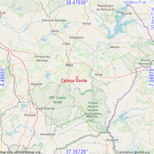
Cabeça Gorda GPS coordinates[2]
37° 55' 26.436" North, 7° 47' 34.44" West
| Map corner | latitude | longitude |
|---|---|---|
| Upper-left | 38.47656°, | -8.49603° |
| Center: | 37.92401°, | -7.7929° |
| Lower-right: | 37.36728°, | -7.08978° |
| Map W x H: | 123.3×123.3 km | = 76.6×76.6mi |
| max Lat: | 42.11337° ⇑85% North |
| Cabeça Gorda: | 37.92401° |
| min Lat: | ⇓15% South 32.6448° |
| min Long | Cabeça Gorda | max Long |
| -31.17847° | -7.7929° | -6.27308° |
| W 85.2%⇐ | ⇒14.8% E |
Elevation
Elevation of Cabeça Gorda is 189 m = 620 ft, and this is 12 m = 39 ft above average elevation for this country.
| Max E: |
1008 m = 3307 ft | 32.5% |
| Cabeça Gorda | 189 m 620 ft | |
| Avg. | 177 m = 581 ft | |
Min E: |
-128 m = -420 ft | 67.5% |
See also: Portugal elevation on elevation.city.
Geographical zone
Cabeça Gorda is located in North temperate zone (between Tropic of Cancer and the Arctic Circle). Distance of this Northern Tropic circle is 1610.8 km =1000.9 mi to South.| Distance of | km | miles | from Cabeça Gorda |
|---|---|---|---|
| North Pole | 5790.3 | 3597.9 | to North |
| Arctic Circle | 3184.4 | 1978.7 | to North |
| Tropic Cancer | 1610.8 | 1000.9 | to South |
| Equator | 4216.8 | 2620.2 | to South |


Nearby cities:
15 places around Cabeça Gorda: (largest is in red/bold)
• Beja
11.9 km =7.4 mi,  328°
328°
• Beringel
22.3 km =13.9 mi,  311°
311°
• Cuba
28.2 km =17.5 mi,  342°
342°
• Faro do Alentejo
28.2 km =17.5 mi, 332°
• Ferreira do Alentejo
25.3 km =15.7 mi,  303°
303°
• Mombeja
24.2 km =15 mi, 297°
• Neves
11.1 km =6.9 mi,  350°
350°
• Penedo Gordo
12.8 km =8 mi, 301°
• Salvada
2.2 km =1.4 mi,  46°
46°
• Santa Clara de Louredo
8.7 km =5.4 mi, 307°
• Santa Vitória
21.1 km =13.1 mi,  283°
283°
• Serpa
17.3 km =10.7 mi,  81°
81°
• São Brissos
21.3 km =13.2 mi,  320°
320°
• São Matias
21.3 km =13.2 mi, 344°
• Trigaches
24.3 km =15.1 mi, 319°
Sources, notices
• [Note1] Compared only with cities in Portugal existing in our database
• [Src1] Map data: © OpenStreetMap contributors (CC-BY-SA)
• [Src2] Other city data from geonames.org with taken over terms of usage.
• [Src3] Geographical zone / Annual Mean Temperature by Robert A. Rohde @ Wikipedia
