Moura geodata
Moura (Beja) is a seat of a second-order administrative division; located in Portugal in Europe/Lisbon (GMT+1) time zone. With population of 9,360 people, there are 234 cities with bigger population in this country. Compared to other cities in Portugal, 82.8% of cities are located further ↑North; 94% of cities are located further ←West and 67.9% of cities have lower elevation than Moura. Note1


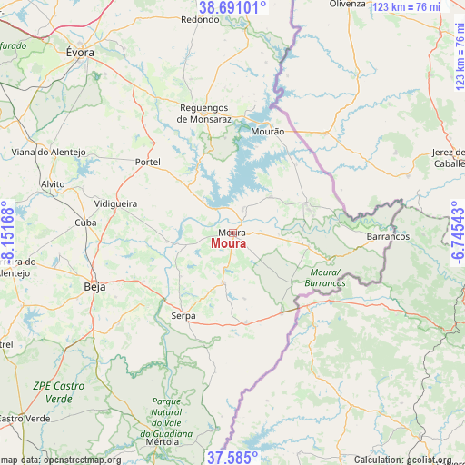
Moura GPS coordinates[2]
38° 8' 24.36" North, 7° 26' 54.816" West
| Map corner | latitude | longitude |
|---|---|---|
| Upper-left | 38.69101°, | -8.15168° |
| Center: | 38.1401°, | -7.44856° |
| Lower-right: | 37.585°, | -6.74543° |
| Map W x H: | 123×123 km | = 76.4×76.4mi |
| max Lat: | 42.11337° ⇑82.8% North |
| Moura: | 38.1401° |
| min Lat: | ⇓17.2% South 32.6448° |
| min Long | Moura | max Long |
| -31.17847° | -7.44856° | -6.27308° |
| W 94%⇐ | ⇒6% E |
Elevation
Elevation of Moura is 190 m = 623 ft, and this is 13 m = 43 ft above average elevation for this country.
| Max E: |
1008 m = 3307 ft | 32.1% |
| Moura | 190 m 623 ft | |
| Avg. | 177 m = 581 ft | |
Min E: |
-128 m = -420 ft | 67.9% |
See also: Portugal elevation on elevation.city.
Geographical zone
Moura is located in North temperate zone (between Tropic of Cancer and the Arctic Circle). Distance of this Northern Tropic circle is 1634.9 km =1015.9 mi to South.| Distance of | km | miles | from Moura |
|---|---|---|---|
| North Pole | 5766.3 | 3583 | to North |
| Arctic Circle | 3160.4 | 1963.8 | to North |
| Tropic Cancer | 1634.9 | 1015.9 | to South |
| Equator | 4240.8 | 2635.1 | to South |


Nearby cities:
15 places around Moura: (largest is in red/bold)
• Aldeia Nova de São Bento
24.1 km =15 mi,  171°
171°
• Barrancos
41.3 km =25.7 mi,  90°
90°
• Beja
38.9 km =24.2 mi,  249°
249°
• Cabeça Gorda
38.6 km =24 mi,  231°
231°
• Cuba
38.9 km =24.2 mi,  274°
274°
• Faro do Alentejo
43.1 km =26.8 mi, 271°
• Mourão
28.6 km =17.8 mi,  18°
18°
• Neves
34.5 km =21.4 mi, 247°
• Portel
28.9 km =18 mi,  309°
309°
• Reguengos de Monsaraz
32.6 km =20.3 mi,  346°
346°
• Salvada
36.3 km =22.6 mi, 231°
• Santa Clara de Louredo
41.6 km =25.8 mi,  243°
243°
• Serpa
25.2 km =15.7 mi,  211°
211°
• São Matias
35.8 km =22.2 mi,  264°
264°
• Vidigueira
31.7 km =19.7 mi,  284°
284°
Sources, notices
• [Note1] Compared only with cities in Portugal existing in our database
• [Src1] Map data: © OpenStreetMap contributors (CC-BY-SA)
• [Src2] Other city data from geonames.org with taken over terms of usage.
• [Src3] Geographical zone / Annual Mean Temperature by Robert A. Rohde @ Wikipedia
