Pêra geodata
Pêra (Faro) is a populated place; located in Portugal in Europe/Lisbon (GMT+1) time zone. With population of 1,951 people, there are 653 cities with bigger population in this country. Compared to other cities in Portugal, 93.8% of cities are located further ↑North; 66.6% of cities are located further ←West and 74.9% of cities have higher elevation than Pêra. Note1


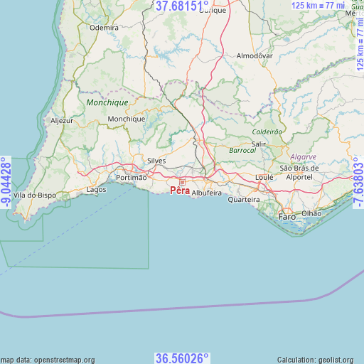
Pêra GPS coordinates[2]
37° 7' 22.656" North, 8° 20' 28.14" West
| Map corner | latitude | longitude |
|---|---|---|
| Upper-left | 37.68151°, | -9.04428° |
| Center: | 37.12296°, | -8.34115° |
| Lower-right: | 36.56026°, | -7.63803° |
| Map W x H: | 124.7×124.7 km | = 77.5×77.5mi |
| max Lat: | 42.11337° ⇑93.8% North |
| Pêra: | 37.12296° |
| min Lat: | ⇓6.2% South 32.6448° |
| min Long | Pêra | max Long |
| -31.17847° | -8.34115° | -6.27308° |
| W 66.6%⇐ | ⇒33.4% E |
Elevation
Elevation of Pêra is 41 m = 135 ft, and this is 136 m = 446 ft below average elevation for this country.
| Max E: |
1008 m = 3307 ft | 74.9% |
| Avg. | 177 m = 581 ft | |
| Pêra | 41 m = 135 ft | |
Min E: |
-128 m = -420 ft | 25.1% |
See also: Portugal elevation on elevation.city.
Geographical zone
Pêra is located in North temperate zone (between Tropic of Cancer and the Arctic Circle). Distance of this Northern Tropic circle is 1521.8 km =945.6 mi to South.| Distance of | km | miles | from Pêra |
|---|---|---|---|
| North Pole | 5879.4 | 3653.3 | to North |
| Arctic Circle | 3273.5 | 2034.1 | to North |
| Tropic Cancer | 1521.8 | 945.6 | to South |
| Equator | 4127.7 | 2564.8 | to South |


Nearby cities:
15 places around Pêra: (largest is in red/bold)
• Albufeira
8.9 km =5.5 mi,  115°
115°
• Alcantarilha
0.9 km =0.6 mi,  331°
331°
• Algoz
5.6 km =3.5 mi,  36°
36°
• Armação de Pêra
2.7 km =1.7 mi,  211°
211°
• Carvoeiro
11.6 km =7.2 mi,  255°
255°
• Estômbar
13 km =8.1 mi,  281°
281°
• Ferreiras
9.2 km =5.7 mi,  85°
85°
• Guia
3.8 km =2.4 mi,  78°
78°
• Lagoa
10 km =6.2 mi, 277°
• Olhos de Água
13.7 km =8.5 mi,  105°
105°
• Paderne
13.9 km =8.6 mi,  63°
63°
• Porches
5.4 km =3.4 mi,  274°
274°
• Silves
11.3 km =7 mi,  310°
310°
• São Bartolomeu de Messines
15.6 km =9.7 mi,  17°
17°
• Tunes
8.7 km =5.4 mi, 56°
Sources, notices
• [Note1] Compared only with cities in Portugal existing in our database
• [Src1] Map data: © OpenStreetMap contributors (CC-BY-SA)
• [Src2] Other city data from geonames.org with taken over terms of usage.
• [Src3] Geographical zone / Annual Mean Temperature by Robert A. Rohde @ Wikipedia
